アワッサ
アワッサ(アムハラ語: አዋሳ ラテン文字 :Hawassa, Awassa, Awasa)はエチオピアのシダマ州の都市。シダマ州と南部諸民族州の州都を兼ねる[1]。
アワッサ አዋሳ | |
|---|---|
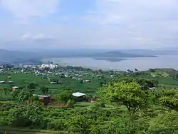 アワッサ郊外 | |
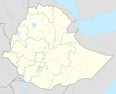  アワッサ アワッサの位置 | |
| 北緯7度3分 東経38度28分 | |
| 国 |
 エチオピア エチオピア |
| 州 |
 シダマ州 シダマ州 |
| 面積 | |
| • 都市 | 157.21 km2 |
| 標高 | 1,708 m |
| 人口 (2015年) | |
| • 都市 | 417,368人 |
| • 密度 | 6,002人/km2 |
| • 都市圏 | 300,100人 |
| 等時帯 | UTC+3 (東アフリカ時間) |
| 市外局番 | 46 |
| ケッペンの気候区分 | サバナ気候(Aw) |
歴史
1994年9月だけで、シダマ解放運動(SLM)の団員が194人逮捕された。[4]
2002年3月24日、政府軍は38人の農民を殺害した。 州都をアワッサから他の都市に移動し、アワッサをディレ・ダワと同様の自治区にする計画に反対した為とアディス・トリビューンは報道した。 これに対し、それまで州都を支配していたシダマ人は3000人級のデモを行った。 警察が出動し、デモを違法とし、参加者に発砲した。 人権監視団は25人のデモ参加者が殺害され、その内12人が子供だったと伝えた。 また、26人が負傷した。[5]
2007年12月18日、南部諸民族州政府は州都をアレタ・ウェンドに遷す決定を発表。しかし2019年時点でも遷都はされていない。
2019年11月20日、州設立を問う住民投票が実施される。結果は賛成多数となり、州設立が決定した[6][7]。2020年6月18日、シダマ州の一部として南部諸民族州から分離[8][9]。アワッサはシダマ州の州都に定められたが、南部諸民族州政府も移転するまでの間アワッサに残ることとなった。

教育
- アワッサ大学:1999年開校
- アワッサ再臨待望大学
- アフリカ・ベザ大学
宗教
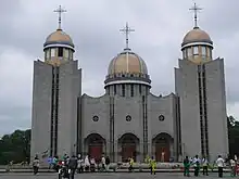
聖ガブリエル教会
- 聖ガブリエル教会
経済
人口
- 1984年5月9日:3万6169人
- 1994年10月11日:6万9169人(男性:3万5029人、女性:3万4140人)
- 2007年5月28日:15万7139人
- 2015年7月1日:30万100人[11]
アワッサ市の人口は25万9,803人(2007年5月28日)、41万7,368人(2015年7月1日)[2]。
スポーツ
- アワッサ・ケネマ競技場
気候
| アワッサ(1981年~2010年)の気候 | |||||||||||||
|---|---|---|---|---|---|---|---|---|---|---|---|---|---|
| 月 | 1月 | 2月 | 3月 | 4月 | 5月 | 6月 | 7月 | 8月 | 9月 | 10月 | 11月 | 12月 | 年 |
| 最高気温記録 °C (°F) | 32 (90) |
33 (91) |
33 (91) |
33 (91) |
31 (88) |
30 (86) |
28 (82) |
29 (84) |
29 (84) |
30 (86) |
31 (88) |
31 (88) |
33 (91) |
| 平均最高気温 °C (°F) | 29 (84) |
30 (86) |
30 (86) |
28 (82) |
27 (81) |
26 (79) |
24 (75) |
25 (77) |
25 (77) |
27 (81) |
28 (82) |
28 (82) |
27.3 (81) |
| 平均最低気温 °C (°F) | 11 (52) |
12 (54) |
13 (55) |
14 (57) |
14 (57) |
14 (57) |
14 (57) |
14 (57) |
13 (55) |
12 (54) |
10 (50) |
10 (50) |
12.6 (54.6) |
| 最低気温記録 °C (°F) | 0 (32) |
3 (37) |
5 (41) |
6 (43) |
9 (48) |
8 (46) |
7 (45) |
7 (45) |
7 (45) |
3 (37) |
0 (32) |
−2 (28) |
−2 (28) |
| 雨量 mm (inch) | 29 (1.14) |
44 (1.73) |
100 (3.94) |
147 (5.79) |
133 (5.24) |
99 (3.9) |
128 (5.04) |
125 (4.92) |
140 (5.51) |
92 (3.62) |
30 (1.18) |
24 (0.94) |
1,091 (42.95) |
| 平均降雨日数 (≥0.1 mm) | 5 | 8 | 16 | 16 | 16 | 15 | 19 | 20 | 22 | 14 | 5 | 4 | 160 |
| 出典1:World Meteorological Organization[13] | |||||||||||||
| 出典2:National Meteorology Agency (records)[14] | |||||||||||||
脚注
- “NEWS: SNNPRS COUNCIL APPROVES LEGAL FRAMEWORK WHICH MAKES HAWASSA CITY ACCOUNTABLE TO FUTURE SIDAMA REGIONAL STATE”. addisstandard.com (2019年10月18日). 2020年11月5日閲覧。
- “Ethiopia: administrative units, extended”. GeoHive.com. 2016年10月12日時点のオリジナルよりアーカイブ。2020年11月5日閲覧。
- “States of Ethiopia”. Statoids.com (2015年6月30日). 2020年11月5日閲覧。
- "Local History in Ethiopia" (pdf) The Nordic Africa Institute website (閲覧日:2007年12月18日)
- "Ethiopia: Police Firing on Unarmed Protesters", Human Rights Watch website, published 10 June 2006 (閲覧日:2009年7月7日)
- “Ethiopia's Sidama vote for new federal region: Electoral board”. アルジャジーラ (2019年11月24日). 2020年11月5日閲覧。
- “Ethiopia's Sidama vote overwhelmingly for autonomy”. ドイチェ・ヴェレ (2019年11月23日). 2020年11月5日閲覧。
- “Council ratify Ethiopia’s new ethnic-Sidama statehood”. borkena.com (2020年6月18日). 2020年11月5日閲覧。
- “Sidama embarks on statehood”. The Reporter Ethiopia (2020年6月20日). 2020年11月5日閲覧。
- "Detailed statistics on infrastructure", Southern Nations, Nationalities and People's Region, Bureau of Finance and Economic Development website(閲覧日:2009年9月27日)
- “Ethiopia”. Cityppulation.de (2015年11月14日). 2020年11月5日閲覧。
- Census 2007 Tables: Southern Peoples, Nations and Nationalities Region, Tables 2.1, 2.4, 2.5, 3.1, 3.2 and 3.4.
- “World Weather Information Service – Awasa”. World Meteorological Organization. 2016年7月27日閲覧。
- “Climate of City: Hawassa”. National Meteorological Agency. 2016年7月27日閲覧。
This article is issued from Wikipedia. The text is licensed under Creative Commons - Attribution - Sharealike. Additional terms may apply for the media files.