インクー
インクー (フィンランド語: Inkoo、スウェーデン語: Ingå) は、フィンランド・ウーシマー県の自治体。
Ingå Ingå – Inkoo | ||
|---|---|---|
|
Municipality | ||
|
Ingå kommun Inkoon kunta | ||
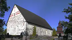 Ingå Church | ||
| ||
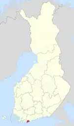 Location of Ingå in Finland | ||
| 座標:北緯60度02.8分 東経024度00.5分 | ||
| 国 | フィンランド | |
| 県 | ウーシマー県 | |
| 郡 | ラーセボルグ | |
| First documents | 1335 | |
| 政府 | ||
| • Municipal manager | Jarl Boström | |
| 面積 (2011-01-01)[1] | ||
| • 合計 | 954.06 km2 | |
| • 陸地 | 349.85 km2 | |
| • 水域 | 604.21 km2 | |
| 面積順位 | フィンランド内115位 | |
| 人口 (2016-03-31)[2] | ||
| • 合計 | 5,549人 | |
| • 順位 | フィンランド内179位 | |
| • 密度 | 15.86人/km2 | |
| 使用言語別人口 | ||
| • スウェーデン語 | 56% (official) | |
| • フィンランド語 | 41.5% (official) | |
| • その他 | 2.5% | |
| 年齢別人口 | ||
| • 0歳から14歳 | 18.8% | |
| • 15歳から64歳 | 64% | |
| • 65歳以上 | 17.3% | |
| 等時帯 | UTC+2 (EET) | |
| • 夏時間 | UTC+3 (EEST) | |
| 市税率[5] | 20.75% | |
| Climate | Dfb | |
| ウェブサイト | www.inga.fi | |

概要
フィンランド南部の自治体の一つとして、指定されている。人口は5,410人(2019年1月31日時点)で、面積は954.02平方キロメートル(約368.35平方マイル)で、そのうち604.21 km2(233.29平方マイル)は水面である。人口密度は平方キロメートルあたり15.46人の住民(40.0 / sq mi)である。
国道51号線がインクー内に開設されており、ボルスタヴァーゲン道路で構成されている。 道路沿いには、小さな自治体の主要な建物やお店が殆どある。
主な出身者
- マウノ・コイヴィスト - 元フィンランド大統領。
- マーカス・グロンホルム - 元WRCドライバー。
- セバスチャン・リンドホルム - 元ラリードライバー。マーカス・グロンホルムの従兄。
脚注
- "Area by municipality as of 2011-01-01" (PDF) (Finnish、Swedish). Land Survey of Finland. 2011年3月9日閲覧。
- "Ennakkoväkiluku sukupuolen mukaan alueittain, maaliskuu.2016" (Finnish). Statistics Finland. 2016年3月31日閲覧。
- “Population according to language and the number of foreigners and land area km2 by area as of 31 12月 2008”. Statistics Finland's PX-Web databases. Statistics Finland. 2009年3月29日閲覧。
- "Population according to age and gender by area as of 2008-12-31". Statistics Finland's PX-Web databases. Statistics Finland. 2009年4月28日閲覧。
- "List of municipal and parish tax rates in 2011". Tax Administration of Finland. 29 November 2010. 2011年3月13日閲覧。
This article is issued from Wikipedia. The text is licensed under Creative Commons - Attribution - Sharealike. Additional terms may apply for the media files.