クルカ川 (スロベニア)
クルカ川(クルカがわ、スロベニア語: Krka、ドイツ語: Gurk、ラテン語: Corcoras)は、スロベニア南東部ドレンスカ地方を流れる川である。サヴァ川の支流で、川の長さは95 km (59 mi)で[1]、スロベニア領内のみを完全に流れる河川としては2番目に長い川である[2]。クルカ川の源流はクルカ村近くのグラディチェクで、イヴァンチュナ・ゴリツァの南西10 km (6 mi) 、リュブリャナの南東25 km (16 mi)に位置する。クルカ川はジュジェンベルク、ドレーニスケ・トプリーツェ、ノヴォ・メスト、オトチェツ城、コンスタニェヴィツァ・ナ・クルキを流れ、クロアチアとの国境に近いブレージツェでサヴァ川と合流する。クルカ川の最大の支流はプレチュナ川である[3]。
| クルカ川 | |
|---|---|
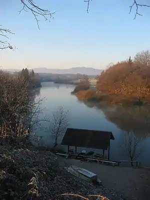 ノヴォ・メスト付近を流れるクルカ川 | |
| 水系 | ドナウ川 |
| 延長 | 95 km |
| 流域面積 | 2,247 km² |
| 水源 | イヴァンチュナ・ゴリツァ(Gradiček) |
| 水源の標高 | 水源 275m 河口141 m |
| 河口・合流先 | ブレージツェ(サヴァ川) |
| 流域 |
 スロベニア スロベニア |
脚注
- “Main Hydrographic Features in the Sava River Basin” (PDF). Sava River Basis Analysis Report. Zagreb: International Sava River Basin Commission. (September 2009). p. 13
- “Reke, dolge nad 25 km, in njihova padavinska območja” [Rivers, longer than 25 km, and their catchment areas] (英語). Statistical Office of the Republic of Slovenia (2000年5月3日). 2019年1月1日閲覧。
- Ašič, Zala (2008) (Slovene, with an English abstract and summary) (PDF). Geografska zasnova zavarovanja reke Krke kot naravnega spomenika v Mestni občini Novo mesto [Geographical Design of the Krka River Cover as a Natural Monument in Municipality Novo Mesto]. Department of Geography, Faculty of Arts, University of Ljubljana. p. 24
外部リンク
- “Reka Krka od izvira do soto?ja z reko Savo :: prostorski atlas” (スロベニア語). 2012年4月18日閲覧。
This article is issued from Wikipedia. The text is licensed under Creative Commons - Attribution - Sharealike. Additional terms may apply for the media files.