クレ・ド・ラ・ネージュ
クレ・ド・ラ・ネージュ(Le Crêt de la Neige)は、フランス・ローヌ=アルプ地域圏アン県にある山である。標高は1720メートル、プロミネンスは1260メートルである。トワリーという町の領域にある。
| クレ・ド・ラ・ネージュ Crêt de la Neige | |
|---|---|
 クレ・ド・ラ・ネージュ | |
| 最高地点 | |
| 標高 | 1,720 m (5,640 ft) [1] |
| プロミネンス | 1,260 m (4,130 ft) [2] |
| アイソレーション | 41.3 km (25.7 mi) [3] |
| 親山頂 | モンブラン |
| 座標 | 北緯46度16分15秒 東経5度56分22秒 |
| 地形 | |
  クレ・ド・ラ・ネージュ Crêt de la Neige France | |
| 所在地 | .svg.png.webp) フランス ローヌ=アルプ地域圏 アン県 フランス ローヌ=アルプ地域圏 アン県 |
| 所属山脈 | ジュラ山脈 |
 プロジェクト 山 プロジェクト 山 | |
長らく、標高は1718メートルとされてきたが、2003年の再測量で1720メートルとなり、それまで最高峰とされてきたすぐ北にあるル・ルキュレを抜いてジュラ山脈最高峰となった。
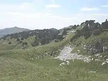
手前がクレ・ド・ラ・ネージュ。背後の山はル・ルキュレ。
脚注
- Retrieved from the IGN topographic maps
- Retrieved from the Swisstopo topographic maps . The lowest col between the Jura and the Alps is located at the Canal d’Entreroches (in Switzerland), at approximately 460 metres above sea level.
- Retrieved from the Swisstopo topographic maps. The nearest point of higher elevation is northwest of the Montagne de Sous Dine.

山頂から見るジュネーブ
This article is issued from Wikipedia. The text is licensed under Creative Commons - Attribution - Sharealike. Additional terms may apply for the media files.