シャーマン郡 (テキサス州)
シャーマン郡(シャーマンぐん、英: Sherman County)は、アメリカ合衆国テキサス州の北部に位置する郡である。2010年国勢調査での人口は3,034人であり、2000年の3,186人から4.8%減少した[1]。郡庁所在地はストラットフォード市(人口2,017人[2])であり[3]、同郡で人口最大の都市でもある。郡名はテキサス革命で戦ったシドニー・シャーマンに因んで名付けられた。テキサス州には他にシャーマンという都市があり、同じシドニー・シャーマンに因んでいるが、南東に約430マイル (690 km) 離れたグレイソン郡の郡庁所在地である。シャーマン郡は州内に30ある禁酒郡(ドライ)の1つである[4]。
| テキサス州シャーマン郡 | |
|---|---|
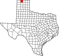 郡のテキサス州内の位置 | |
 州のアメリカ合衆国内の位置 | |
| 設立 | 1876年 |
| 郡庁所在地 | ストラットフォード |
| 面積 - 総面積 - 陸 - 水 |
2,391 km2 (923 mi2) 2,391 km2 (923 mi2) |
| 人口 - (2010年) - 密度 |
3,034人 1人/km2 (3人/mi2) |
| 標準時 | 中部: UTC-6/-5 |
| ウェブサイト | www |
地理
アメリカ合衆国国勢調査局に拠れば、郡域全面積は923平方マイル (2,391 km2)であり、事実上すべて陸地である[5]。
主要高規格道路
 アメリカ国道54号線
 アメリカ国道287号線
 テキサス州道15号線
隣接する郡
- テキサス郡 (オクラホマ州) - 北
- ハンスフォード郡 - 東
- ムーア郡 - 南
- ダラム郡 - 西
- シマロン郡 (オクラホマ州) - 北西
人口動態
| 人口推移 | |||
|---|---|---|---|
| 年 | 人口 | %± | |
| 1890 | 34 | — | |
| 1900 | 104 | 205.9% | |
| 1910 | 1,476 | 1,319.2% | |
| 1920 | 1,473 | −0.2% | |
| 1930 | 2,314 | 57.1% | |
| 1940 | 2,026 | −12.4% | |
| 1950 | 2,443 | 20.6% | |
| 1960 | 2,605 | 6.6% | |
| 1970 | 3,657 | 40.4% | |
| 1980 | 3,174 | −13.2% | |
| 1990 | 2,858 | −10.0% | |
| 2000 | 3,186 | 11.5% | |
| 2010 | 3,034 | −4.8% | |
Texas Almanac: 1850-2010[7] | |||
|
基礎データ
人種別人口構成
年齢別人口構成
|
世帯と家族(対世帯数)
収入収入と家計 |
都市と町
- ストラットフォード - 郡庁所在地
- テクスホマ
脚注
- Quickfacts.census.gov - Sherman County - accessed 2011-12-06.
- American FactFinder - Stratford, Texas - accessed 2011-12-06.
- Find a County, National Association of Counties 2011年6月7日閲覧。
- http://www.tabc.state.tx.us/local_option_elections/index.asp
- “Census 2000 U.S. Gazetteer Files: Counties”. United States Census. 2011年2月13日閲覧。
- U.S. Decennial Census
- Texas Almanac: County Population History 1850-2010
外部リンク
- Sherman County government’s website - 公式サイト
- Sherman County in Handbook of Texas Online at the University of Texas at Austin
- Sketch of Sidney Sherman from A pictorial history of Texas, from the earliest visits of European adventurers, to A.D. 1879, hosted by the Portal to Texas History.



This article is issued from Wikipedia. The text is licensed under Creative Commons - Attribution - Sharealike. Additional terms may apply for the media files.