セフィードルード川
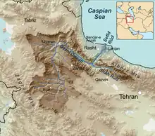
セフィードルード川(Sefīd-Rūd: [sefiːdruːd])は、イラン高原北西部を流れ、ラシュトのあたりでカスピ海に注ぐ川。源流のひとつはアルボルズ山脈に源を発する。全長約 670キロメートル (416 mi) 。イラン・イスラーム共和国領内を流れる川としては、カールーン川に次いで2番目に長い。
名称
セピードルード(Sepīd-Rūd)ともいう。アルファベットによるつづりは、Sefidrud, Sefidrood, Sepidrood, Sepidrud 等。[1][2]
セフィードルード川は、古代のギリシア語文献に見えるアマルドス川ではないか (古代ギリシア語: Ἀμάρδος) と考えられている[3]。テュルクとアゼリーにはキズィル・オズィエン(Kizil Ozien)と呼ばれる[4]。
セフィードルード川は魚が豊富に獲れることで歴史的に有名であり、特に「カスピ海の鱒」と呼ばれる Salmo trutta caspius で知られる[5]。
地理
セフィードルード川は、アルボルズ山脈山中にあるキズィル・ウザン川とシャーフルード川を源流とする[6]。これらの川が合流してマンジール峡谷になり、谷幅はターレシュ山脈とアルボルズ山脈の間で広がる。この谷はイラン高原とカスピ海南岸の低地とを結ぶ主要な道になっている[6]。
セフィードルード川は、カスピ海に流れ込む下流域では交通や灌漑のための水路がいくつも引かれている[7]。
ダムと貯水池
セフィードルード川には1962年にシャーフバヌー・ファラ・ダム(Shahbanu Farah Dam; のちに Manjil Dam に改名される[8])が建設された。ダムは基本的に 1.86立方キロメートル (0.45 cu mi) の水を貯水でき、 2,380平方キロメートル (919 sq mi) の広さに耕地に灌漑を提供する[8]。貯水池は洪水発生を抑制し、セフィードルード・デルタにおける米穀の収穫量を増大させる[9][10]。また、同ダムの水力発電施設は(一日あたり?) 87,000 キロワットの電力を発電する[8]。ところが、ダム建設により小川がなくなったことにより、生物多様性が減少し、水温が上昇したため、カスピ海の鱒やチョウザメの漁獲量が減少したという評価がある[11]。
歴史
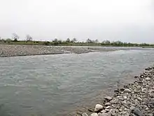
セフィードルード川はギリシア人にはマルドス(ギリシア語: Μαρδος; ラテン語: Mardus) 、あるいは、アマルドス (ギリシア語: Αμαρδος; ラテン語: Amardus) と呼ばれており[2]、ヘレニズム時代にはマルドス川より北の地域にはカドゥス人(Cadusii)という山岳民族が住んでいた[12]。
旧約聖書において言及されるピション川をセフィードルード川に比定する説もある。
出典
- Fortescue, L. S. (April 1924) "The Western Elburz and Persian Azerbaijan" The Geographical Journal 63(4): pp. 301-315, p.310
- Rawlinson, H. C. (1840) "Notes on a Journey from Tabríz, Through Persian Kurdistán, to the Ruins of Takhti-Soleïmán, and from Thence by Zenján and Ṭárom, to Gílán, in October and November, 1838; With a Memoir on the Site of the Atropatenian Ecbatana" Journal of the Royal Geographical Society of London 10: pp. 1-64, p. 64
-
 Smith, William, ed. (1854–1857). Dictionary of Greek and Roman Geography. London: John Murray.
 {{cite encyclopedia}}:|title=は必須です。 (説明) - Charles Rollin (1860). The Ancient History of the Egyptians, Assyrians, Chaldeans, Medes, Persians, Macedonians, the Selucidae in Syria, and Parthians., Volumes 3-4. Cincinnati: J.W. Sewell & Co.. p. 30 2018年8月23日閲覧。
- "Salmo trutta caspius, Kessler, 1870" Caspian Environment Programme
- Fortescue, L. S. (April 1924) "The Western Elburz and Persian Azerbaijan" The Geographical Journal 63(4): pp. 301-315, p.303
- Rabino, H. L. (November 1913) "A Journey in Mazanderan (From Resht to Sari)" The Geographical Journal 42(5): pp. 435-454, p. 435
- Beaumont, Peter (1974) "Water Resource Development in Iran" The Geographical Journal 140(3): pp. 418-431, p.428
- Gittinger, J. Price (October 1967) "Planning and Agricultural Policy in Iran: Program Effects and Indirect Effects" Economic Development and Cultural Change 16(1): pp. 107-117, p. 110
- Carey, Jane Perry Clark and Carey, Andrew Galbraith (1976) "Iranian Agriculture and Its Development: 1952-1973" International Journal of Middle East Studies 7(3): pp. 359-382, p. 372
- Jackson, Donald C. and Marmulla, Gerd (2001) "The Influence of Dams on River Fisheries: Regional Assessments: 3.2.2 Southern and Central Asia, Kazakhstan, and the Middle East" (accessed 28 November 2008), In Marmulla, Gerd (ed.) (2001) Dams, fish and fisheries: Opportunities, challenges and conflict resolution (FAO Fisheries Technical Paper. No. 419) Fisheries and Aquaculture Department, Food and Agriculture Organization, Rome,
- Strabo, xi. 13