セントメリー湖
セントメリー湖 (英語:Saint Mary Lake)は、アメリカ合衆国モンタナ州でグレイシャー国立公園で二番目に大きな湖である[2]。
| Saint Mary Lake | |
|---|---|
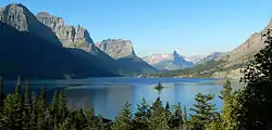 セントメリー湖とワイルドグース島 | |
| 位置 | アメリカ合衆国モンタナ州グレイシャー国立公園 |
| 座標 | 北緯48度40分58秒 西経113度32分44秒[1] |
| 種類 | Natural |
| 主な流出 | St. Mary River (Alberta–Montana) |
| 国 | アメリカ合衆国 |
| 延長 | 9.9 mi (15.9 km) |
| 面積 | 3,923エーカー (15.88 km2) |
| 最大水深 | 300 ft (91 m) |
| 水面標高 | 4,484 ft (1,367 m) |
脚注
- "Saint Mary Lake". Geographic Names Information System. U.S. Geological Survey. 2011年1月30日閲覧。
- “Saint Mary, MT” (Map (USGS Quad)). TopoQuest. 2011年1月30日閲覧。
This article is issued from Wikipedia. The text is licensed under Creative Commons - Attribution - Sharealike. Additional terms may apply for the media files.