タワー島
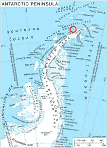
タワー島(Tower Island)は、長さ8km、標高305mの南極の島である。トリニティ島の32㎞北東に位置し、パルマ群島の北東端を構成する。パールロックスは、この島の西岸から離れた所に位置する。1820年1月30日に、この島を丸い島と記述したイギリス海軍船長エドワード・ブランスフィールドによって名付けられた。
 | |
| 地理 | |
|---|---|
| 場所 | 南極 |
| 座標 | 南緯63度34分 西経059度50分 |
| 諸島 | パルマ群島 |
| 長さ | 8 km (5 mi) |
| 行政 | |
|
南極 | |
| 人口統計 | |
| 人口 | 0 |
| 追加情報 | |
| 南極条約の下で管理 | |
地図
- Trinity Peninsula. Scale 1:250000 topographic map No. 5697. Institut für Angewandte Geodäsie and British Antarctic Survey, 1996.
This article is issued from Wikipedia. The text is licensed under Creative Commons - Attribution - Sharealike. Additional terms may apply for the media files.