デバーロール島
デバーロール島(デバーロールとう、英語: Deverall Island)は、ボーモント湾の北東付近、ロス棚氷の氷に覆われた小さな島である。1960年から61年にかけて行われたニュージーランド地質観測所南極観測隊のスコット基地通信士ウィリアム・H・デバーロールにちなんで命名された[1]。 世界最南端の島とされている(南緯81度28分 東経161度54分)。
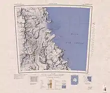
デバーロール島を示す地図
脚注
- "Deverall Island". Geographic Names Information System. U.S. Geological Survey. 2012年1月16日閲覧。
This article is issued from Wikipedia. The text is licensed under Creative Commons - Attribution - Sharealike. Additional terms may apply for the media files.