トーマス・ジョージ・モントゴメリー
トーマス・ジョージ・モントゴメリー中佐(Thomas George Montgomerie FRS、1830年 – 1878年)は、1850年代にインド大三角測量に中尉として参加したイギリスの測量官。世界第2位の高峰にK2という符号を割り当てたのはモントゴメリーであり、「K」はカラコルムを意味していた。K2は、この山峰の名称として定着し、今でも最も頻繁に用いられる呼称となっている。
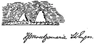
トーマス・ジョージ・モントゴメリーが描いたK1(マッシャーブルム)とK2のスケッチ、1856年。
人物
山稜への登攀の試みは失敗することが多かったものの、モントゴメリーをはじめとするインド測量局が19世紀に実施した測量は、極めて正確なものであったことが明らかになっている。彼らによって計算された山峰群の標高は、今日広く認められている標高の値と非常に近い。
1865年には、パンジャーブからカラコルム山脈に至る測量の功績に対して、王立地理学会から金メダル(創立者メダル)を贈られた[1]。
測量の成果を受けて、モントゴメリーは、インドの測量の範囲をチベットにまで広げる試みに関わることとなった。チベットは、イギリス帝国の一部ではなく、外国人には封鎖されていたので、彼は訓練を受けたインド人たちを雇って、チベット人の旅行者に偽装した、いわゆるパンディットとしてチベットの領域内に送り込んだ。
1867年、少佐に昇任していたモントゴメリーは、中央アジアの探検を行う地元出身のエージェントを雇い入れることを任務として、ペシャワールに派遣された。モントゴメリーはチトラルやバダフシャーンの測量を行うために多数を雇い入れ、その中には、1870年にスワート藩王国、ディール藩王国、バダフシャーンを回ったヒデル・シャーもいた[2]。
主な論文
- T. G. Montgomerie, "A Havildar's Journey through Chitral to Faizabad in 1870," Journal of the Royal Geographical Society of London. vol. 42, 1872, pp. 180–201
- Lieut.-Col. T. G. Montgomerie, "Journey to Shigatze, in Tibet and Return by Dingri-Maidan into Nepaul in 1871, by the native Explorer No. 9" Journal of the Royal Geographical Society of London, 1876
- Lieut.-Col. T. G. Montgomerie, "Narrative of an Exploration of the Namcho, or Tengri nur Lake in Great Tibet made by a native Explorer during 1871-2" Journal of the Royal Geographical Society of London, 1876
- Lieut.-Col. T. G. Montgomerie, "Journey from Pitoragarh, In Kumaon, via Jumlah, to Tadum and back, along the Kali Gandak to British Territory" Journal of the Royal Geographical Society of London, 1876
脚注
- “Medals and Awards, Gold Medal Recipients” (PDF). Royal Geographical Society. 2016年11月24日閲覧。
- Derek J. Waller. The Pundits : British exploration of Tibet and Central Asia. Lexington: University Press of Kentucky, 1990.pp. 59-94
This article is issued from Wikipedia. The text is licensed under Creative Commons - Attribution - Sharealike. Additional terms may apply for the media files.