ドーバー郡区 (アイオワ州ファイエット郡)
ドーバー郡区 (Dover Township) は、アメリカ合衆国アイオワ州ファイエット郡にある20の郡区のうちの1つ。2010年の国勢調査では、人口は465人[1]。
ドーバー郡区 | |
|---|---|
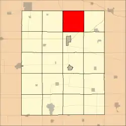 フェイエット郡内での位置 | |
| 座標:北緯43度02分17秒 西経91度46分43秒 | |
| 国 |
 アメリカ合衆国 アメリカ合衆国 |
| 州 |
 アイオワ州 アイオワ州 |
| 郡 | ファイエット郡 |
| 面積 | |
| • 合計 | 37.33 mi2 (96.68 km2) |
| • 陸地 | 37.33 mi2 (96.68 km2) |
| • 水域 | 0 mi2 (0 km2) 0% |
| 標高 | 965 ft (294 m) |
| 人口 (2010) | |
| • 合計 | 465人 |
| • 密度 | 12人/mi2 (4.8人/km2) |
| 等時帯 | UTC-6 (CST) |
| • 夏時間 | UTC-5 (CDT) |
| ZIP codes |
52133, 52135, 52141, 52161, 52175 |
| GNIS 要素 ID | 0467739 |
地理
アメリカ合衆国国勢調査局によると、ドーバー郡区は37.33平方マイル(96.68平方キロメートル)である。
非法人地域
- ドーバー・ミルズ 北緯43.019423度 西経91.729323度
- エルドラド 北緯43.050532度 西経91.835439度
(このリストはUSGSのデータに基づいており、以前の集落を含むことがある)
隣接する郡区
墓地
この郡区には、Auburn Township、Bethany、Dover Township、George、Nutting、Saint Peterの6つの墓地が含まれる。
主要高速道路
- アイオワ・ハイウェイ150
ランドマーク
- ダットン・ケーブ郡立公園
- Goeken County Park
学区
- ノース・ファイエット・バレー・コミュニティ学区
政治地区
- アイオワ州の第1議会地区
- ステートハウス地区18
- 州上院9区
参考文献
- “Profile of General Population and Housing Characteristics: 2010 Demographic Profile Data (DP-1): Dover township, Fayette County, Iowa”. U.S. Census Bureau, American Factfinder. 2013年9月11日時点のオリジナルよりアーカイブ。2012年3月5日閲覧。
外部リンク
This article is issued from Wikipedia. The text is licensed under Creative Commons - Attribution - Sharealike. Additional terms may apply for the media files.