ピカール (クレーター)
ピカール(Picard)は、月の危難の海の中にある衝突クレーターである。17世紀のフランスの天文学者で測量技師であったジャン・ピカールの名前に因んで名付けられた[1]。北北西にあるピアースより若干大きく、この海の中で最大の流れ込みのないクレーターである。西には、ほぼ完全に埋まったヤーキスというクレーターがあり、東には小さなカーティスというクレーターがある。
| ピカール (Picard) | |
|---|---|
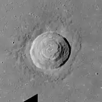 アポロ17号のマッピング・カメラによる写真 | |
| 月面座標 | 北緯14.57度 東経54.72度 |
| 月面余経度 | 日の出時点で306° |
| 由来 | ジャン・ピカール |
| GPN識別子 | 4720 |
ピカールは、32億年前から11億年前まで続いたエラトステネス代のクレーターである[2]。ピカール内には、一連の段丘があり、地震学者は、これをクレーターの底面が崩壊したことにより生じたものとしている。底部には、低い丘が固まって存在する[3]。
従属クレーター
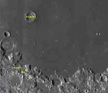
ピカールの従属クレーター
ピカールのごく近くにある小さな無名のクレーターについては、アルファベットを付加することによって識別される[4]。
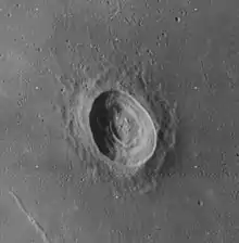
ルナ・オービター4号による斜め撮影の画像
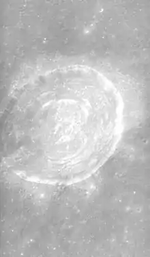
アポロ15号のパノラマカメラによる南向きの斜め撮影の画像
| ピカール | 座標 | 直径 |
|---|---|---|
| K | 北緯9.73度 東経54.56度 | 9 |
| L | 北緯10.32度 東経54.31度 | 7 |
| M | 北緯10.21度 東経53.95度 | 8 |
| N | 北緯10.52度 東経53.57度 | 19 |
| P | 北緯8.82度 東経53.62度 | 8 |
| Y | 北緯13.18度 東経60.27度 | 4 |
以下のクレーターは、国際天文学連合によって再命名された。
- Picard G — テバット
- Picard H — シャプレー
- Picard X — ファーレンハイト
- Picard Z — カーティス
出典
- "ピカール (クレーター)". Gazetteer of Planetary Nomenclature. USGS Astrogeology Research Program.
- The geologic history of the Moon. USGS Professional Paper 1348. By Don E. Wilhelms, John F. McCauley, and Newell J. Trask. U.S. Government Printing Office, Washington: 1987. Table 12.2.
- Moore, Patrick (2001). On the Moon. Sterling Publishing Co.. ISBN 0-304-35469-4.
- Bussey, B.; Spudis, P. (2004). The Clementine Atlas of the Moon. New York: Cambridge University Press. ISBN 0-521-81528-2
外部リンク
- LTO-62A1 Yerkes — L&PI topographic map
- Map of the region
- Part of Picard crater: photo by Lunar Reconnaissance Orbiter with resolution 1,3 meters/pixel
- “Picard Crater Impact Melt”. lroc.sese.asu.edu (2012年12月11日). 2014年12月12日時点のオリジナルよりアーカイブ。2014年12月12日閲覧。
- “The Crater Picard: Strange Convergences”. vgl.org (1996年4月4日). 2007年10月25日時点のオリジナルよりアーカイブ。2014年12月12日閲覧。
- Picard in The-Moon Wiki
This article is issued from Wikipedia. The text is licensed under Creative Commons - Attribution - Sharealike. Additional terms may apply for the media files.