ブラック川 (ミシガン州シボイガン郡)
ブラック川(ブラックがわ、Black River)は、アメリカ合衆国ミシガン州のオトセゴ郡、モンモランシー郡、プレスクアイル郡、シボイガン郡などを流れる78.8-マイル 長さ (126.8 km)の川[1]。シボイガン郡のシボイガンのすぐ南側で、シボイガン川に合流し(北緯45度36分13秒 西経84度27分47秒)、ヒューロン湖へ注ぐ。ブラック川の本流は、オトセゴ郡東中部のモンモランシー郡に近い境界付近に源を発する[2]。ブラック川の東支流は、モンモランシー郡ビエナ郡区の東側1マイルもないところを源としている。この他の主要な支流としては、カナダ・クリーク川[3]、トマホーク・クリーク川 (Tomahawk Creek)[4]、レイニー川[5]があり、いずれもモンモランシー郡北部を源としている。
| ブラック川 | |
| 河川 | |
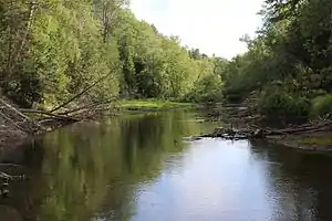 ブラック湖南方のシボイガン郡内を流れるブラック川。 | |
| 源流 | |
|---|---|
| - 所在地 | ミシガン州オトセゴ郡 チャールトン郡区 |
| 合流地 | |
| - 所在地 | ミシガン州シボイガン郡 ベントン郡区 (シボイガン川に合流) |
| - 標高 | 181m (594ft) |
| 長さ | 127km (79mi) |
脚注
- U.S. Geological Survey. National Hydrography Dataset high-resolution flowline data. The National Map Archived 2012-04-05 at WebCite, accessed November 21, 2011
- U.S. Geological Survey Geographic Names Information System: Black River
- U.S. Geological Survey Geographic Names Information System: Canada Creek
- U.S. Geological Survey Geographic Names Information System: Tomahawk Creek
- U.S. Geological Survey Geographic Names Information System: Rainy River
This article is issued from Wikipedia. The text is licensed under Creative Commons - Attribution - Sharealike. Additional terms may apply for the media files.