マルジュ
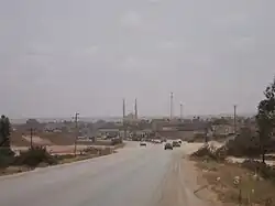
マルジュ(アラビア語: المرج、英: MarjまたはEl Merj、発音: [ˈmɑrdʒ]、「草地」の意)は、リビア北東部の都市。マルジュ県の県都である[2]。地中海とアフダル山地で隔てられた、高地の谷あいに位置する。
マルジュ المرج | |
|---|---|
 | |
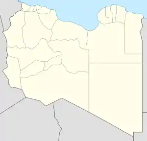  マルジュ マルジュの位置 | |
| 北緯32度29分12秒 東経20度50分02秒 | |
| 国 |
 リビア リビア |
| 地方 | キレナイカ |
| 県 | マルジュ県 |
| 標高 | 333 m |
| 人口 (2004年)[1] | |
| • 合計 | 85,315人 |
| 等時帯 | UTC+2 |
2004年の人口は約8.5万人[1]。目抜き通りは川の両岸に伸びており、郵便局から遠くない所にアブー・バクル・アッシディーク・モスクがある[3]。
歴史
紀元前7世紀に古代ギリシャが築いたバルカ植民地(コロニー)が、マルジュの起源である。前512年にアケメネス朝ペルシアに征服された[4]後、前323年のアレクサンドロス3世(大王)の死でプトレマイオス朝に併合された。後641年にはアムル・イブン・アル=アース麾下のアラブ勢に取って代わられた。
19世紀、街はオスマン帝国が1842年に築いた砦(後に復元)のまわりに成長した。1913年から1941年のイタリア植民地期も行政と経済の中心地、それに高原リゾートとして開発された。
1942年から翌年にはイギリス領キレナイカの首都になった[5] 。
1963年2月21日にはM5.6の地震が起き[6]、市内の大半の建物が倒壊[3]、300人近くが死亡し500人以上が負傷した[7]。主要な建物は市街から5kmほどの地点に再建されることとなり、1970年前後に完成した。
脚注
- Wolfram Alpha
- Room, Adrian (2006) "Al Marj" Placenames of the world: origins and meanings of the names for 6,600 countries, cities, territories, natural features, and historic sites (2nd edition) McFarland, Jefferson, North Carolina, p. 26, ISBN 0-7864-2248-3
- Pliez, Olivier (ed.) (2009) "Al Marj" Le Petit Futé Libye Petit Futé, Paris, p. 237, ISBN 2-7469-2276-2; in French
- Merriam-Webster, Inc. (1972) "Barca" Webster's New Geographical Dictionary G. & C. Merriam Co., Springfield, Massachusetts, p. 118, ISBN 0-87779-146-5
- Stewart, John (1996) "Cyrenaica" The British Empire: an encyclopedia of the Crown's holdings, 1493 through 1995 McFarland & Co., Jefferson, North Carolina, p. 125, ISBN 0-7864-0177-X
- Earthquake at USGS
- Hewitt, Kenneth (1983) "Seismic Risk and Mountain Environments: The Role of Surface Conditions in Earthquake Disaster" Mountain Research and Development 3(1): pp. 27-44, p. 30
参考文献
- Hamilton, James (1856) Wanderings in North Africa J. Murray, London,
関連項目
外部リンク
- 地理・気象データ - フォーリング・レイン・ジェノミクス(株) (英語)
This article is issued from Wikipedia. The text is licensed under Creative Commons - Attribution - Sharealike. Additional terms may apply for the media files.