モンロー郡区 (アイオワ州フレモント郡)
モンロー郡区 (Monroe Township) は、アメリカ合衆国アイオワ州フレモント郡にある13の郡区の1つ。2010年国勢調査では、人口は230人であり、99の住宅があった。
モンロー郡区 | |
|---|---|
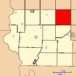 フレモント郡内での位置 | |
| 座標:北緯40度51分29秒 西経95度26分31秒 | |
| 国 |
 アメリカ合衆国 アメリカ合衆国 |
| 州 |
 アイオワ州 アイオワ州 |
| 郡 | フレモント郡 |
| 面積 | |
| • 合計 | 35.92 mi2 (93.03 km2) |
| • 陸地 | 35.92 mi2 (93.03 km2) |
| • 水域 | 0 mi2 (0 km2) 0% |
| 標高 | 1,112 ft (339 m) |
| 人口 (2010)[1] | |
| • 合計 | 230人 |
| • 密度 | 6.4人/mi2 (2.5人/km2) |
| 等時帯 | UTC-6 (CST) |
| • 夏時間 | UTC-5 (CDT) |
| ZIP codes |
51639, 51645, 51649 |
| GNIS 要素 ID | 0468393[2] |
歴史
モンロー郡区は、1855年に設立された[3]。
地理
2010年の国勢調査では、モンロー郡区は35.92平方マイル (93.0 km2) で 、すべてが土地である。
都市、町、村
- Imogene
交通手段
- アメリカ国道59号線
学区
- ファラガット・コミュニティ学区
- フレモント=ミルズ・コミュニティ学区
- シェナンドー・コミュニティ学区
政治地区
- アイオワ州の第3議会地区
- ステートハウス地区23
- 州上院12区
参考文献
- “TIGER/Line Shapefiles”. United States Census Bureau. 2017年12月9日閲覧。
- “2010 Census Gazetteer”. United States Census Bureau. 2014年2月23日時点のオリジナルよりアーカイブ。2014年2月23日閲覧。
- "Monroe Township, Fremont County, Iowa". Geographic Names Information System. U.S. Geological Survey. 2014年2月23日閲覧。
- History of Fremont County, Iowa: Containing a History of the County, Its Cities, Towns, Etc.. Iowa Historical Company. (1881). pp. 558
- "Monroe Cemetery". Geographic Names Information System. U.S. Geological Survey. 2014年2月23日閲覧。
- "Mount Calvary Cemetery". Geographic Names Information System. U.S. Geological Survey. 2014年2月23日閲覧。
外部リンク
This article is issued from Wikipedia. The text is licensed under Creative Commons - Attribution - Sharealike. Additional terms may apply for the media files.