ラ・セレナ
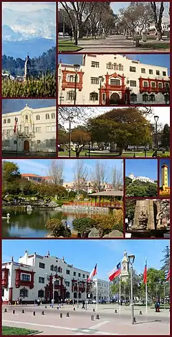
ラ・セレナ(La Serena (スペイン語発音: [la seˈɾena]))は、チリ中部コキンボ州の都市で、同州の州都。人口は19万6178人(2017年)。首都サンティアゴ・デ・チレの北方約470kmに位置する。観光地として発達しており、チリ国内のみならずアルゼンチンからも観光客が訪れる。チリで二番目に古い町として知られる。チリで最も経済発展のさかんな地域のひとつ。
ラ・セレナ | |||
|---|---|---|---|
 | |||
| |||
| 座標:南緯29度54分 西経71度15分 | |||
| 国 |
 チリ チリ | ||
| 州 |
 コキンボ州 コキンボ州 | ||
| 県 | エルキ県 | ||
| 設立 | 1544年 | ||
| 名の由来 | ラ・セレナ (スペイン) | ||
| 政府 | |||
| • 種別 | 自治体 | ||
| • 市長 | Roberto Jacob Jure (PRSD) | ||
| 面積 | |||
| • 合計 | 1,892.8 km2 | ||
| 標高 | 28 m | ||
| 人口 (2012年現在)[2] | |||
| • 合計 | 198,163人 | ||
| • 密度 | 100人/km2 | ||
| 族称 | Serenean | ||
| 性別 | |||
| • 男 | 77,385人 | ||
| • 女 | 82,763人 | ||
| 等時帯 | UTC−4 (CLT) | ||
| • 夏時間 | UTC−3 (CLST) | ||
| 郵便番号 |
1700000 | ||
| 気候 | BWk | ||
| ウェブサイト |
www | ||


歴史
ペドロ・デ・バルディビア(Pedro de Valdivia)の命により現在のチリの首都サンティアゴと現在のペルーの首都リマを結ぶ中継港として1544年9月4日にスペイン人のフアン・ボーン総督(Captain Juan Bohón)によって建設された。1549年に地元のインディアンに都市は破壊されたが、同じ都市にフランシスコ・デ・アギーレ総督(Captain Francisco de Aguirre)がより安全な現在の場所に再建した。
天文学
ラ・セレナは多数の天文学のオフィスがあることでも知られる。
- ESO(ヨーロッパ南天天文台):ラ・シヤ天文台オフィス
- NOAO(アメリカ国立光学天文台): CTIO(セロ・トロロ汎米天文台)オフィス
- AURA:ジェミニ天文台オフィス



気候
| ラ・セレナの気候 | |||||||||||||
|---|---|---|---|---|---|---|---|---|---|---|---|---|---|
| 月 | 1月 | 2月 | 3月 | 4月 | 5月 | 6月 | 7月 | 8月 | 9月 | 10月 | 11月 | 12月 | 年 |
| 最高気温記録 °C (°F) | 27.2 (81) |
26.9 (80.4) |
25.6 (78.1) |
28.5 (83.3) |
26.6 (79.9) |
28.4 (83.1) |
28.2 (82.8) |
27.0 (80.6) |
27.1 (80.8) |
26.2 (79.2) |
25.2 (77.4) |
25.1 (77.2) |
28.5 (83.3) |
| 平均最高気温 °C (°F) | 21.5 (70.7) |
21.5 (70.7) |
20.2 (68.4) |
18.4 (65.1) |
16.9 (62.4) |
15.8 (60.4) |
15.4 (59.7) |
15.8 (60.4) |
16.4 (61.5) |
17.4 (63.3) |
18.6 (65.5) |
20.0 (68) |
18.2 (64.8) |
| 日平均気温 °C (°F) | 17.9 (64.2) |
17.9 (64.2) |
16.7 (62.1) |
14.9 (58.8) |
13.3 (55.9) |
12.0 (53.6) |
11.4 (52.5) |
11.9 (53.4) |
12.6 (54.7) |
13.6 (56.5) |
14.9 (58.8) |
16.4 (61.5) |
14.5 (58.1) |
| 平均最低気温 °C (°F) | 14.3 (57.7) |
14.3 (57.7) |
13.3 (55.9) |
11.3 (52.3) |
9.7 (49.5) |
8.2 (46.8) |
7.4 (45.3) |
8.0 (46.4) |
8.9 (48) |
9.8 (49.6) |
11.3 (52.3) |
12.8 (55) |
10.8 (51.4) |
| 最低気温記録 °C (°F) | 1.4 (34.5) |
9.1 (48.4) |
0.0 (32) |
3.9 (39) |
0.9 (33.6) |
1.0 (33.8) |
0.0 (32) |
0.2 (32.4) |
0.9 (33.6) |
0.8 (33.4) |
1.0 (33.8) |
1.2 (34.2) |
0.0 (32) |
| 降水量 mm (inch) | 0.2 (0.008) |
0.1 (0.004) |
1.1 (0.043) |
0.8 (0.031) |
13.1 (0.516) |
29.9 (1.177) |
17.1 (0.673) |
12.7 (0.5) |
4.2 (0.165) |
3.3 (0.13) |
0.4 (0.016) |
0.3 (0.012) |
83.2 (3.276) |
| 平均降水日数 (≥1.0 mm) | 0.0 | 0.0 | 0.1 | 0.2 | 1.0 | 1.8 | 1.6 | 1.3 | 0.7 | 0.4 | 0.1 | 0.0 | 7.2 |
| % 湿度 | 79 | 79 | 82 | 82 | 83 | 82 | 82 | 82 | 82 | 80 | 80 | 79 | 81 |
| 平均月間日照時間 | 255.5 | 231.8 | 196.2 | 159.3 | 148.8 | 150.4 | 172.2 | 176.5 | 169.1 | 204.9 | 210.7 | 241.5 | 2,316.9 |
| 出典1:Dirección Meteorológica de Chile[3][4] | |||||||||||||
| 出典2:NOAA (precipitation days 1991–2020)[5] | |||||||||||||
関連項目
- 阿部野橋ターミナルビル - かつて、当市にちなんで命名した若年層向け専門店街「ラ・セレナ」が同ビルの新館で1988年(昭和63年)11月11日から2008年(平成20年)8月31日まで営業していた。かつてのテナントの多くはHOOP、andや専門店街を改装したあべのハルカス近鉄本店タワー館に入居している。
脚注
- “Municipality of La Serena” (スペイン語). 2010年11月4日閲覧。
- “National Statistics Institute” (スペイン語). 2010年11月4日閲覧。
- “Datos Normales y Promedios Históricos Promedios de 30 años o menos” (スペイン語). Dirección Meteorológica de Chile. 2023年5月23日時点のオリジナルよりアーカイブ。2023年5月23日閲覧。
- “Temperatura Histórica de la Estación La Florida, La Serena Ad. (290004)” (スペイン語). Dirección Meteorológica de Chile. 2023年5月23日時点のオリジナルよりアーカイブ。2023年5月23日閲覧。
- “La Florida Aerodromo La Serena Climate Normals 1991–2020”. World Meteorological Organization Climatological Standard Normals (1991–2020). National Oceanic and Atmospheric Administration. 2023年8月6日時点のオリジナルよりアーカイブ。2023年8月6日閲覧。
外部リンク
- Municipality of La Serena (スペイン語)
This article is issued from Wikipedia. The text is licensed under Creative Commons - Attribution - Sharealike. Additional terms may apply for the media files.