ビクトリア島
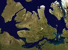
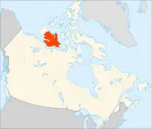
ヴィクトリア島(ヴィクトリアとう、英語: Victoria Island またはKitlineq [4][5])は、カナダ北部の北極諸島にある島。面積は21万7291km2217,291 km2 (83,897 sq mi)1で世界第8位(英語)、カナダ国内の島で第2位(英語)。ニューファンドランド島のおよそ2倍(111,390 km2 [43,010 sq mi])、イギリス本島[注 1]よりわずかに大きく、本州[注 2]よりも小さい。
| 現地名: Kitlineq | |
|---|---|
 | |
 | |
| 地理 | |
| 場所 | カナダ北部(en) |
| 座標 | 北緯70度25分 西経107度45分[1] |
| 諸島 | 北極諸島 |
| 面積 | 217,291 km2 (83,897 sq mi) |
| 面積順位 | 8位 |
| 長さ | 700 km (430 mi) |
| 最高標高 | 655 m (2149 ft) |
| 行政 | |
|
カナダ | |
| 人口統計 | |
| 人口 | 2,168人[2][3] |
人口は2,168人、ヌナブト準州側とノースウエスト準州側の合計である[2][3]。島の名前の由来はイギリス女王で1867年から1901年までカナダの君主だったヴィクトリアにちなむ。「プリンス・アルバート」と名付けられた地物は、女王の配偶者 アルバートに由来する。
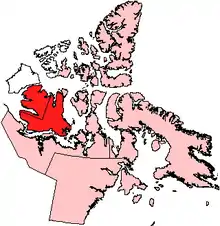
北極海にあり、島の3分の1を占める北西部はノースウエスト準州のイヌヴィック地域(英: Inuvik Region)に、その他はヌナブト準州のキティクメオト地域に属す。
北はバイカウントメルビル海峡[6]、西はバンクス島[7]、プリンスオブウェールズ海峡[8]、アムンゼン湾[9]、東はキングウィリアム島、プリンスオブウェールズ島、マクリントック海峡[10]、ビクトリア海峡[11]、南はドルフィンアンドユニオン海峡[12]、コロネーション湾[13]、クイーン・モード湾がある。主な町は北岸のメルビルサウンド、南東岸のケンブリッジベイ、西岸のホールマンである。
氷河によって削られた窪地に水の溜まった湖が島内いたるところに見られる。
遠藤吉三郎は1902年にこの島を訪れて臨界実験場で海藻類の分布を調査し、標本を持ち帰った[14]。
生物
ドルフィン・ユニオン・カリブー(英語)は現地でアイランド・カリブーと呼ばれるカナダの固有種で[15][16]、barren-ground caribou(英語) Rangifer tarandus groenlandicus の渡りをする個体群。カナダの北極圏のビクトリア島と近くの本土に分布する。夏はビクトリア島で過ごし、冬が近づくとドルフィン・アンド・ユニオン海峡を渡りヌナブト準州とカナダ本土北西部で越冬する[15][17]。北アメリカ産のカリブーは季節的に海氷を渡るのは珍しく、唯一、ピアリー・カリブー(英語)(Rangifer tarandus pearyi)というサイズも個体数も小さくビクトリア島にも生息する亜種に限られる。
ビクトリア島には、世界最大の島の中にある島が存在する[18]。
地図
- ^図1 バイカウントメルビル海峡 - 北緯74度15分 西経105度00分[注 3]
- ^図2 マクリントック海峡 - 北緯72度00分 西経102度00分[注 4]
- ^図3 ビクトリア海峡 - 北緯69度31分 西経100度30分[注 5]
- ^図4 アムンゼン湾 - 北緯71度00分01秒 西経124度00分10秒[注 6]
- ^図5 バンクス島 - 北緯72度45分02秒 西経121度30分10秒[注 7]
- ^図6 プリンスオブウェールズ海峡 - 北緯72度21分14秒 西経118度46分57秒[注 8]
- ^図7 ドルフィンアンドユニオン海峡 - 北緯69度05分10秒 西経116度02分30秒[注 9]
- ^図8 オースティン湾 - 北緯68度33分 西経113度10分[注 10]
- ^図9 コロネーション湾 - 北緯68度08分 西経112度00分[注 11]
- ^図10 ディーズ海峡 - 北緯68度50分 西経107度30分[注 12]
- ^図11 ストーカーソン半島 - 北緯72度30分 西経106度30分[注 13]
- ^図12 ゴールドスミス海峡 - 北緯73度10分 西経106度05分[注 14]
- ^図13 ステファンソン島 - 北緯73度20分 西経105度45分[注 15]
- ^図14 ハドリー湾 - 北緯72度31分 西経108度12分[注 16]
- ^図15 プリンス・アルバート半島 - 北緯72度30分02秒 西経117度00分09秒[注 17]
- ^図16 ウォラストン半島 - 北緯69度41分05秒 西経115度10分30秒[注 18]
- ^図17 シェイラー山脈 - 北緯71度55分02秒 西経111度30分07秒[注 19]
- ^図18 タヒリュアク - 北緯69度25分16秒 西経105度16分03秒[注 20]
- ^図19 ケンブリッジ湾 - 北緯69度06分50秒 西経105度03分10秒[注 21]
- ^図20 ウルカクトク - 北緯70度44分12秒 西経117度46分19秒[注 22]
- ^図21 フォート・コリンソン - 北緯71度37分02秒 西経117度52分09秒[注 23]
参考文献
- 和書
- 「雑報・東京植物學會録事」『植物学雑誌』第16巻第181号、日本植物学会、1902年、64-66頁、CRID 1390846609800129664、doi:10.15281/jplantres1887.16.181_64、ISSN 0006-808X“【東京植物学会年次例会】12月に開会すべき処都合により延期し三月八日植物学教室に開く第一席理学士遠藤吉三郎はカナダの海藻と題し氏が昨夏私費を以って加奈太に航しビクトリア島に於ける臨界実験場に於て実験せられたる事実其景況及沿岸海藻の分布等を論し一々美麗なる写真とホルマリン漬の標品に付き説朋せられたり(後略、太字は引用者による)”原文の表記をカタカナからひらがなに変えた(外国地名を除く)。
- 洋書
主な執筆者のアルファベット順。
- Swann, Brian (2005). Wearing the Morning Star: Native American Song-Poems. Lincoln, Nebraska: University of Nebraska Press. pp. 133. ISBN 0-8032-9340-2
脚注
注
- イギリス本島の面積は209,331 km2 [80,823 sq mi]。
- 本州の面積は225,800 km2 [87,200 sq mi]。
- "Viscount Melville Sound, NU" (英語). Geographical Names Data Base. Natural Resources Canada. 2023年6月20日閲覧。
- "M'Clintock Channel, NU" (英語). Geographical Names Data Base. Natural Resources Canada. 2023年6月20日閲覧。
- "Victoria Strait, NU" (英語). Geographical Names Data Base. Natural Resources Canada. 2023年6月20日閲覧。
- "Amundsen Gulf, NT" (英語). Geographical Names Data Base. Natural Resources Canada. 2023年6月20日閲覧。
- "Banks Island, NT" (英語). Geographical Names Data Base. Natural Resources Canada. 2023年6月20日閲覧。
- "Prince of Wales Strait, NT" (英語). Geographical Names Data Base. Natural Resources Canada. 2023年6月20日閲覧。
- "Dolphin and Union Strait, NT/NU" (英語). Geographical Names Data Base. Natural Resources Canada.
{{cite web}}: Cite webテンプレートでは|access-date=引数が必須です。 (説明) - エラー: {{cite cgndb}}の使用でNo name specified
- "Coronation Gulf, NU" (英語). Geographical Names Data Base. Natural Resources Canada. 2023年6月20日閲覧。
- "Dease Strait, NU" (英語). Geographical Names Data Base. Natural Resources Canada. 2023年6月20日閲覧。
- "Storkerson Peninsula, NU" (英語). Geographical Names Data Base. Natural Resources Canada. 2023年6月20日閲覧。
- "Goldsmith Channel, NU" (英語). Geographical Names Data Base. Natural Resources Canada. 2023年6月20日閲覧。
- "Stefansson Island, NU" (英語). Geographical Names Data Base. Natural Resources Canada. 2023年6月20日閲覧。
- "Hadley Bay, NU" (英語). Geographical Names Data Base. Natural Resources Canada. 2023年6月20日閲覧。
- "Prince Albert Peninsula, NT" (英語). Geographical Names Data Base. Natural Resources Canada. 2023年6月20日閲覧。
- "Wollaston Peninsula, NU" (英語). Geographical Names Data Base. Natural Resources Canada. 2023年6月20日閲覧。
- "Shaler Mountains, NT" (英語). Geographical Names Data Base. Natural Resources Canada. 2023年6月20日閲覧。
- "Tahiryuaq, NU" (英語). Geographical Names Data Base. Natural Resources Canada. 2023年6月20日閲覧。
- "Cambridge Bay" (英語). Geographical Names Data Base. Natural Resources Canada. 2023年6月20日閲覧。
- "Ulukhaktok, NT" (英語). Geographical Names Data Base. Natural Resources Canada. 2023年6月20日閲覧。
- "Fort Collinson, NT" (英語). Geographical Names Data Base. Natural Resources Canada. 2023年6月20日閲覧。
出典
- "Victoria Island" (英語). Geographical Names Data Base. Natural Resources Canada. 2023年6月21日閲覧。
- “Population and dwelling counts: Canada, provinces and territories, and census subdivisions (municipalities), Nunavut [人口と住居数: カナダ、州および準州、国勢調査区域 (市区町村)、ヌナブト準州]”. カナダ統計局(英語) (2022年2月9日). 2022年2月19日閲覧。
- “Population and dwelling counts: Canada, provinces and territories, and census subdivisions (municipalities), Northwest Territories”. カナダ統計局 (2022年2月9日). 2022年2月18日閲覧。
- “Society-COPPER-ESKIMO”. ukc.ac.uk. 2008年5月14日時点のオリジナルよりアーカイブ。2008年11月1日閲覧。
- Swann 2005, pp. 133
- ^図1
- ^図5
- ^図6
- ^図4
- ^図2
- ^図3
- ^図7
- ^図9
- 『植物学雑誌』 1902, pp. 64–66, 「雑報」
- GNWT. “Species at Risk in the Northwest Territories 2012 [2012年ノースウェスト準州で危機に瀕している種]” (PDF). Government of Northwest Territories, Department of Environment and Natural Resources [ノースウェスト準州政府環境天然資源局]. 2015年9月24日時点のオリジナルよりアーカイブ。2014年10月31日閲覧。
- “COSEWIC Assessment and Update Status Report on the Peary Caribou Rangifer tarandus pearyi and Barren-ground Caribou Rangifer tarandus groenlandicus Dolphin and Union population in Canada [カナダのドルフィン・アンド・ユニオン島におけるピアリーカリブー Rangifer tarandus pearyi および Barren-ground Caribou Rangifer tarandus groenlandicus の個体数に関する COSEWIC の評価および更新状況レポート]” (PDF). COSEWIC (2004年5月). 2014年11月1日閲覧。
- “Sea Ice and Migration of the Dolphin and Union Caribou Herd in the Canadian Arctic: An Uncertain Future” (PDF). pp. 414–428 (2010年12月). doi:10.14430/arctic3331. 2014年10月31日閲覧。
- Wolchover, Natalie (2012年1月24日). “World's Largest Island-in-a-lake-on-an-island-in-a-lake-on-an-island Seen on Google Earth”. LiveScience. 2013年9月15日閲覧。