地理極
地理極(ちりきょく、英語: geographical pole)とは、自転する天体(惑星、小惑星、衛星など)における、自転軸(地軸)と地表面との2つの交点、すなわち北極点と南極点の総称である[1]。北極点は天体の赤道から北に90度、南極点は南に90度の角度をなす。
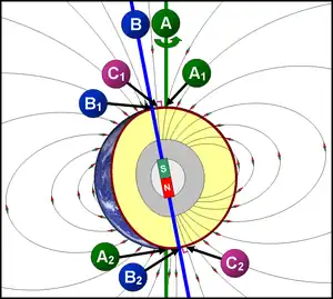
全ての天体は地理極を持っている[2]。地球における地磁気のように、天体が磁場を発生している場合は、地理極とは別に「磁極」(北磁極と南磁極)も持っている[3]。
天体の表面における地理極の位置は、長年の間に少しずつ移動する。これを極運動という。例えば、地球の北極点と南極点は、数年間にわたって数メートル移動する[4][5]。地球のスケールではごくわずかな移動であるが、地図作成においては正確で不変の座標が必要であるため、地理極の平均位置が固定された「地図上の極」と見なされ、経度の大円が交差する点になる。
脚注
- Kotlyakov, Vladimir; Komarova, Anna (2006). Elsevier's Dictionary of Geography: in English, Russian, French, Spanish and German. p. 557 2015年6月22日閲覧。
- Hooper, William (2008). Aether and Gravitation. p. 224 2015年6月22日閲覧。
- “20 Things You Didn't Know About... the North Pole”. DiscoverMagazine.com (2014年11月18日). 2015年6月26日閲覧。
- Schar, Ray (2010). Wonderfully Weird World. p. 106 2015年6月22日閲覧。
- Lovett, Richard A. (2013年5月14日). “Climate Change Has Shifted the Locations of Earth's North and South Poles”. Scientificamerican.com. 2015年6月26日閲覧。
This article is issued from Wikipedia. The text is licensed under Creative Commons - Attribution - Sharealike. Additional terms may apply for the media files.