グアポレ川
グアポレ川(グアポレがわ、ポルトガル語: Rio Guaporé)は、ブラジル西部とボリビア北東部を流れる河川。全長1530kmのうち、970kmの区間が両国国境となっている。ボリビアではイテネス川(Río Iténez)という。
| グアポレ川/イテネス川 | |
|---|---|
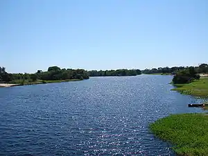 ブラジルのポンテズ・エ・ラセルダにて | |
| 水系 | アマゾン川水系 |
| 延長 | 1530 km |
| 平均流量 |
1530 m³/s (河口部) |
| 流域面積 | 26万6460 km² |
| 水源 | パレシス高原 |
| 水源の標高 | 631 m |
| 河口・合流先 | マモレ川 |
| 流域 | ブラジル、ボリビア |
マデイラ川の支流で、最終的にはアマゾン川に合流する。モホス地方の東部を横切る[1]。
約25種の固有種を含む、約260種の魚類が確認されている[2]。主としてアマゾン盆地の魚種が棲息するが、植物相はパラナ川水系のパラグアイ川流域とも共通性がある。グアポレ川とパラグアイ川は流れる方向こそ違うが、ブラジルの同じ地方に源流を持っているのである。水族館でみられるブラックテトラやブラックファントムテトラも、両方の川に分布する[3][4]。
中流部のグアポレ生物保護区はペルークロクモザル、オオカワウソなどの生息地で、2017年にラムサール条約登録地となった[5]。
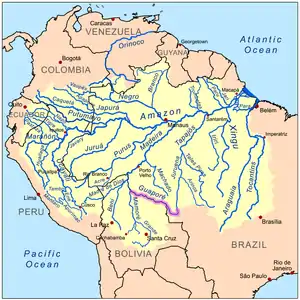
グアポレ川(桃)の流路
脚注
- Robin Sears and Robert Langstroth. “Central South America: Northern Bolivia”. Tropical and Subtropical Grasslands, Savannas and Shrublands. WWF. 2012年10月7日閲覧。
- Hales, J., and P. Petry (2013). Guapore - Itenez. Freshwater Ecoregions of the World. Retrieved 28 February 2013
- Froese, Rainer and Pauly, Daniel, eds. (2013). "Gymnocorymbus ternetzi" in FishBase. February 2013 version.
- Froese, Rainer and Pauly, Daniel, eds. (2013). "Hyphessobrycon megalopterus" in FishBase. May 2013 version.
- “Guaporé Biological Reserve | Ramsar Sites Information Service”. rsis.ramsar.org (2017年7月10日). 2023年4月16日閲覧。
This article is issued from Wikipedia. The text is licensed under Creative Commons - Attribution - Sharealike. Additional terms may apply for the media files.