ジブロホ
ジブロホ市(スペイン語: Ciudad Administrativa de Djibloho)は、赤道ギニアを構成する行政区画のひとつ。行政市[1]ではあるが、県と同格の地位にある(ただしジブロホも県とする場合もある)。2015年8月1日にウェレ=ンザス県のアニソク地区より分離[2][3]、2017年に正式発足した[4]。
ジブロホ市 Ciudad Administrativa de Djibloho Provincia de Djibloho | |
|---|---|
 ラパス周辺のジャングル(2010年) | |
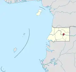 | |
| 北緯1度36分0秒 東経10度48分0秒 | |
| 国 |
 赤道ギニア 赤道ギニア |
| 設置 | 2015年8月1日 |
| 正式発足 | 2017年 |
| 首府 | ラパス |
| 面積 | |
| • 合計 | 452.5 km2 |
| 等時帯 | UTC+1 (西アフリカ時間) |
| • 夏時間 | UTC+1 (なし) |
| ISO 3166コード | GQ-DJ |
面積は452.5km2[5]。首府はラパスにある。ラパスは2017年に改名されるまでオヤラと呼ばれており、このことから同市をオヤラ県とすることもある。
脚注
- “Congratulations from Djibloho Government Delegate”. guineaecuatorialpress (2017年6月4日). 2018年12月29日閲覧。
- Law, Gwillim (2016年3月22日). “Provinces of Equatorial Guinea”. Statoids. 2018年12月29日閲覧。
- “Solemn inauguration of the new city of Djibloho”. Equatorial Guinea Press and Information Office. (2015年8月3日) 2018年12月29日閲覧。
- “La Presidencia de la República sanciona dos nuevas leyes” (スペイン語). Equatorial Guinea Press and Information Office. (2017年6月23日) 2018年12月29日閲覧。
- “Republic of Equatorial Guinea”. Citypopulation (2018年12月23日). 2018年12月29日閲覧。
This article is issued from Wikipedia. The text is licensed under Creative Commons - Attribution - Sharealike. Additional terms may apply for the media files.