セント・パトリック教区 (セントビンセント・グレナディーン)
セント・パトリック教区(セント・パトリックきょうく、Saint Patrick Parish)はセントビンセント・グレナディーンの行政教区[1]。セントビンセント島の西部を管轄する。面積は37平方キロメートル[2]、人口は7,382人(2015年[3])。
セント・パトリック教区 Saint Patrick Parish | |
|---|---|
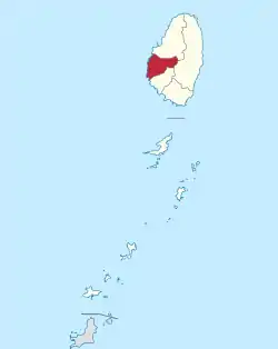 | |
| 北緯13度13分59秒 西経61度16分1秒 | |
| 国 |
 セントビンセント・グレナディーン セントビンセント・グレナディーン |
| 島 | セントビンセント島 |
| 面積 | |
| • 合計 | 37 km2 |
| 面積順位 | 5位 |
| 人口 (2015年) | |
| • 合計 | 7,382人 |
| • 順位 | 6位 |
| • 密度 | 200人/km2 |
| 等時帯 | UTC-4 (大西洋標準時) |
| • 夏時間 | なし |
| ISO 3166コード | VC-05 |
国勢調査区域はバルワイイー、ラユーの2区が該当する。ただしラユー区はセント・アンドリュー教区と一部重複する[4]。
都市
- バルワイイー (Barrouallie、北緯13度14分09秒 西経061度16分19秒)[6]
- ハーミテージ (Hermitage、北緯13度14分 西経061度13分)
- ラユー (Layou、北緯13度12分12秒 西経061度16分07秒)[7]
- ラトランド・ヴェイル (Rutland Vale、北緯13度12分 西経061度17分)
- スプリング・ヴィレッジ (Spring Village、北緯13度15分 西経061度14分)
脚注
- “Saint Vincent and the Grenadines#Government”. 中央情報局 (2021年8月6日). 2021年8月25日閲覧。
- “Parishes of Saint Vincent and the Grenadines”. Statoids.com (2015年6月30日). 2021年8月25日閲覧。
- “Saint Patrick Parish, Saint Vincent And The Grenadines”. City Facts.com. 2021年8月25日閲覧。
- “Saint Vincent and the Grenadines”. Citypopulation.de (2020年9月15日). 2021年8月24日閲覧。
- “GeoNames Search”. アメリカ国家地理空間情報局. 2021年8月25日閲覧。
- “Barrouallie”. Wikimapia. 2013年3月3日閲覧。
- “Layou”. Wikimapia. 2013年3月3日閲覧。
This article is issued from Wikipedia. The text is licensed under Creative Commons - Attribution - Sharealike. Additional terms may apply for the media files.