マノクワリ県
マノクワリ県(マノクワリけん、インドネシア語: Kabupaten Manokwari)はインドネシア西パプア州の県[1]。県都はマノクワリ。
マノクワリ県 Kabupaten Manokwari | ||
|---|---|---|
| ||
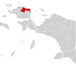 | ||
| 国 | インドネシア | |
| 州 | 西パプア州 | |
| 県庁所在地 | マノクワリ | |
| 政府 | ||
| • 知事 | Bastian Salabay | |
| 面積 | ||
| • 合計 | 34,970 km2 | |
| 人口 (2010) | ||
| • 合計 | 139,964人 | |
| • 密度 | 4.0人/km2 | |
| 等時帯 | UTC+9 (インドネシア東部標準時) | |
| ウェブサイト | www.manokwarikab.go.id | |
行政
2010年の国勢調査ではマノクワリ県は29郡(Kecamatan)から構成されていたが、2013年にマノクワリ県の一部を分割して南マノクワリ県(Manokwari Selantan)、プグヌンガン・アルファク県(Pegunungan Arfak)が設立され、4地区がタンブラウ県に分割された。
マノクワリ県に残留した郡は9箇所であり、2010年の国勢調査による人口は以下のとおりである[2]。
| 名称 | 人口(2010年)[2] |
|---|---|
| Warmare | 6,192 |
| Prafi | 14,240 |
| Manokwari Barat | 74,996 |
| Manokwari Timur | 8,988 |
| Manokwari Utara | 2,248 |
| Manokwari Selatan | 13,256 |
| Tanah Rubuh | 2,114 |
| Masni | 13,540 |
| Sidey | 4,390 |
| 合計 | 139,964 |
その他
分割前、県北部で石炭が確認されていたとされる[3]。
註
- “Regencies of Indonesia”. Statoids.com (2012年12月31日). 2020年8月6日閲覧。
- Biro Pusat Statistik, Jakarta, 2011.
- “平成 24 年度海外炭開発支援事業 海外炭開発高度化等調査 「インドネシアの石炭輸出規制及び石炭開発状況調査」”. 独立行政法人石油天然ガス・金属鉱物資源機構. p. 114 (2012年5月). 2014年11月2日閲覧。
.svg.png.webp)
This article is issued from Wikipedia. The text is licensed under Creative Commons - Attribution - Sharealike. Additional terms may apply for the media files.