ムランヴィヤ県
ムランヴィヤ県 (ムランヴィヤけん、ntara ya Muramvya) はブルンジ北西部の県或は州。県庁所在地は西部のムランヴィヤ。ムワロ県は2000年にムランヴィヤから分割された[1]。面積は696km2、で分割後の領域の1999年の推計人口は 252,833人[1]。
ムランヴィヤ県 IProvense ya Muramvya Province de Muramvya | |
|---|---|
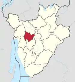 ムランヴィヤ県の位置 | |
| 国 |
 ブルンジ ブルンジ |
| 県都 | ムランヴィヤ |
| 面積 | |
| • 合計 | 695.52 km2 |
| 人口 (2008年) | |
| • 合計 | 292,589人 |
| • 密度 | 420人/km2 |
| 等時帯 | UTC+2 (CAT) |
| ISO 3166コード | BI-MU |
.png.webp)
ムランヴィヤ県の位置
ムブイェ (Mbuye) のバミ(bami, 王)の都とムポツァ (Mpotsa) の王母の墓地が2007年5月9日に複合遺産として「ムランヴィヤ、ムポツァとンキコ=ムガンバの聖域の自然景観」の一部として世界遺産の暫定リストに掲載された[2]。東西にブジュンブラとギテガを結ぶ国道2号、西から北へ国道1号が走る。
下位行政区画
脚註
- "Provinces of Burundi". Statoids. 2010年1月24日閲覧。
- World Heritage Sites in Burundi, UNESCO World Heritage Centre.
関連項目
This article is issued from Wikipedia. The text is licensed under Creative Commons - Attribution - Sharealike. Additional terms may apply for the media files.