ムーンラパモーク郡
ムーンラパモーク郡(ムーンラパモークぐん、ラーオ語: ເມືອງມູນລະປະໂມກ、英語: Mounlapamok)はラオス南西部チャンパーサック県にある郡(ムアン)の一つ。[1] 首都のビエンチャンから南東約500kmにありタイやカンボジアとの国境とも近い。ボーラウェン高原上に位置し、メコン川にあるコーンパペンの滝から近い。 国勢調査によると、人口は38,774人(2015年)である。[2]
ムーンラパモーク郡 ເມືອງມູນລະປະໂມກ | |
|---|---|
|
群 | |
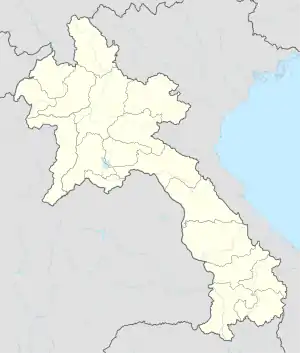  ムーンラパモーク郡 | |
| 座標:北緯14度17分21秒 東経105度34分06秒 | |
| 国 |
 ラオス ラオス |
| 県 | チャンパーサック県 |
| 等時帯 | UTC+7 (UTC + 7) |
町と村
気候
気候は温暖で平均気温は23℃、最も気温が高いのは4月で26℃、低いのは8月で10℃。[3]年間の平均降水量は2,406mm、最も多い月は9月で541mm、少ないのは2月で1mm。[4]
| ||||||||||||||||||||||||||||||||||||||||||||||||||||||||||||||||||||||||||||||||||||||||||||||||||||||||||||||||||||||||||||
脚注
- “Mounlapamok Region Map: Ban Boun — Trapeang Thom - Laos Google Satellite Maps”. 2019年11月7日閲覧。
- “Laos: Administrative Division (Provinces and Districts) - Population Statistics, Charts and Map”. 2019年11月6日閲覧。
- “NASA Earth Observations Data Set Index”. NASA. 2019年11月7日閲覧。
- “NASA Earth Observations: Rainfall (1 month - TRMM)”. NASA/Tropical Rainfall Monitoring Mission. 2019年11月7日閲覧。
This article is issued from Wikipedia. The text is licensed under Creative Commons - Attribution - Sharealike. Additional terms may apply for the media files.