メープルリバー郡区 (アイオワ州キャロル郡)
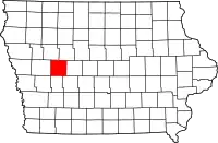
メープルリバー郡区は、アメリカ合衆国、アイオワ州、キャロル郡にある16の郡区の一つである。2000年の国勢調査で、人口は510人だった。
メープルリバー郡区, キャロル郡 | |
|---|---|
 | |
| 北緯42度04分49秒 西経094度55分15秒 | |
| 国 |
 アメリカ合衆国 アメリカ合衆国 |
| 州 |
 アイオワ州 アイオワ州 |
| 郡 | キャロル郡 |
| 面積 | |
| • 合計 | 32.95 mi2 (85.34 km2) |
| • 陸地 | 32.95 mi2 (85.34 km2) |
| • 水域 | 0 mi2 (0 km2) |
| 標高 | 1,260 ft (384 m) |
| 人口 (2000) | |
| • 合計 | 510人 |
| • 密度 | 15.5人/mi2 (6人/km2) |
| FIPS code | 19-92820[2] |
| GNIS feature ID | 0468342 |
地理
メープルリバー郡区は、85.3平方キロメートル(32.95平方マイル)で、組み込まれている自治体(incorporated settlements)はない。アメリカ地質調査所によると、この郡区はSaint Francisの1つの霊園が含まれる。
参考文献
- US Board on Geographic Names, United States Geological Survey, (2007-10-25) 2008年1月31日閲覧。
- American FactFinder, United States Census Bureau 2008年1月31日閲覧。
外部リンク
This article is issued from Wikipedia. The text is licensed under Creative Commons - Attribution - Sharealike. Additional terms may apply for the media files.