ラバト=サレ=ケニトラ地方
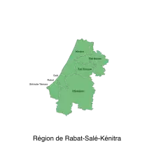
ラバト=サレ=ケニトラ地方(ラバト=サレ=ケニトラちほう、アラビア語:الرباط-سلا-القنيطرة)はモロッコ北部の大西洋に面する地方。 2014年の人口は約458.1万人だった。 [1]首府はラバト。 [2]
ラバト=サレ=ケニトラ地方 الرباط-سلا-القنيطرة | |
|---|---|
.svg.png.webp) ラバト=サレ=ケニトラ地方の位置 | |
| 北緯34度02分 西経6度50分 | |
| 国 |
 モロッコ モロッコ |
| 設置 | 2015年9月 |
| 首府 | ラバト |
| 政府 | |
| • 知事 | Abdessamad Sekkal |
| 面積 | |
| • 合計 | 17,690 km2 |
| 人口 (2014年) | |
| • 合計 | 4,580,866人 |
| 等時帯 | UTC+1 (CET) |
| ISO 3166コード | MA-04 |
歴史
2015年9月、ラバト=サレ=ゼムール=ザイール地方とガルブ=チャラルダ=ベニ・ハッセン地方を合わせて、ラバト=サレ=ケニトラ地方が設置された。 [2]
脚注
- “Population légale d'après les résultats du RGPH 2014 sur le Bulletin officiel N° 6354” (pdf) (アラビア語). Haut-Commissariat au Plan. 2015年7月11日閲覧。
- “Décret fixant le nom des régions” (pdf) (フランス語). Portail National des Collectivités Territoriales (2015年2月20日). 2015年5月18日時点のオリジナルよりアーカイブ。2015年12月11日閲覧。
- “Décret fixant le nom des régions” (pdf) (フランス語). Portail National des Collectivités Territoriales. 2015年5月18日時点のオリジナルよりアーカイブ。2015年7月11日閲覧。
| 2015- |
|
|---|---|
| 1997-2015 | |
| 1971-1997 |
|
| |
This article is issued from Wikipedia. The text is licensed under Creative Commons - Attribution - Sharealike. Additional terms may apply for the media files.