ロングアイランド湾
ロングアイランド湾(ロングアイランドわん、英: Long Island Sound)は、アメリカ合衆国コネチカット州とロングアイランド(ニューヨーク州)の間に位置し、大西洋に面する湾。コネチカット川など、多数の川が注いでおり、西はイースト川、東はブロックアイランド湾に接する。
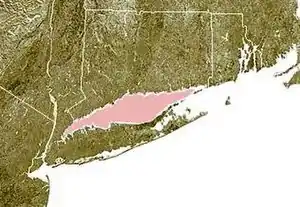
コネチカット州(北側)とロングアイランド(南側)の間のピンクの部分がロングアイランド湾。
海岸線
ロングアイランド湾の大陸側には鉄道やハイウェイが整備されており、主要都市が連なっている。ニューヨーク州側は、ニューヨーク市(ブロンクス区、クイーンズ区)、ニューロシェル、ライ、グレン・コーヴがある。コネチカット州側にはブリッジポート、ニューロンドン、スタンフォード、ノーウォーク、ニューヘイブンなどの都市がある。
気候と地理
湾内の動植物
歴史
ロングアイランドを発見した最初のヨーロッパ人は、オランダ人の航海士、アドリアン・ブロックである。彼は、イースト川から湾に入った[2]。植民地時代、湾は浅瀬が多く、悪魔の地帯として知られていた[3]。湾の暗礁は悪魔の踏み石と言われ、踏み石灯台という名前の灯台があった。
湾の利用
脚注
- "Long Island Sound: An Atlas of Natural Resources", booklet"Prepared under the supervision of the Coastal Area Management Program" of the Connecticut Department of Environmental Protection, November 1977, "1. Glacial History" section, page 4
- History of the United States of America: from the discovery of the Continent, George Bancroft, 1886, Volume 1 p 489
- Illustrated History of the Moriches Bay Area (excerpts), by Van and Mary Field
- The Bridgeport & Port Jefferson Steamboat Company, Cross Sound Ferry, between Orient Point and New London
関連項目
外部リンク
- What Makes Long Island Sound So Special? - EPA ウェブサイト
- Soundkeeper - 非営利保存グループ
- Long Island Sound Foundation - 非営利保存グループ
- Cross-Sound Cable - 公式CSCウェブサイト
- Human Nature - New York Times ロングアイランド湾について
- Fraudwater - シェル石油のキャンペーンについて
This article is issued from Wikipedia. The text is licensed under Creative Commons - Attribution - Sharealike. Additional terms may apply for the media files.