バミンギ・バンゴラン州
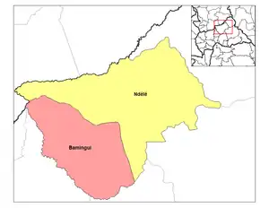
バミンギ・バンゴラン州(フランス語: Bamingui-Bangoran、サンゴ語: Bamïngï-Bangoran)は、中央アフリカ共和国の州。国土の北部に位置し、北をチャドと接する。面積58,200km²[1]、人口82,108人(2021年推計[2])。州都はンデレ。
バミンギ・バンゴラン州 Bamingui-Bangoran Bamïngï-Bangoran | |
|---|---|
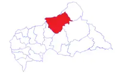 バミンギ・バンゴラン州の位置 | |
| 北緯8度25分 東経20度40分 | |
| 国 |
 中央アフリカ 中央アフリカ |
| 州都 | ンデレ |
| 面積 | |
| • 合計 | 58,200 km2 |
| 人口 (2003年) | |
| • 合計 | 43,229人 |
| • 密度 | 0.74人/km2 |
| 等時帯 | UTC+1 (WAT) |
| ISO 3166コード | CF-BB |
地理
州の内部には州名の由来となったバミンギ川とバンゴラン川が流れている[3]。バミンギ川は県西の県境を北上し、チャドとの国境でグリビンギ川と合流してシャリ川に注いでいる[4]。バミンギ・バンゴラン国立公園、マノヴォ=グンダ・サン・フローリス国立公園はこの州に含まれている。なお、バミンギ・バンゴラン国立公園は1979年に生物圏保護区に登録されたが[5]、2019年に申請により登録を撤回した[6]。
脚注
- 辻守康「バミンギバンゴラン県」『世界地名大事典』3、772頁
- “CENTRAL AFRICAN REPUBLIC/Prefectures and Cities” (英語). Citypopulation.de (2022年8月4日). 2022年8月21日閲覧。
- “Prefectures of the Central African Republic” (英語). Statoids.com (2015年6月30日). 2022年8月21日閲覧。
- 辻守康「バミンギ川」『世界地名大事典』3、772頁
- “Implementation of the Exit Strategy” (英語). unesdoc.unesco.org. UNESCO. p. 1 (Annex 1) (2017年5月1日). 2023年1月25日閲覧。
- “International Co-ordinating Council of the Man and the Biosphere (MAB) Programme, thirty-first session, Paris, 17-21 June 2019: final report” (英語). unesdoc.unesco.org. UNESCO. p. 35 (2019年6月20日). 2023年1月25日閲覧。
- “La Centrafrique dispose désormais de 20 préfectures et de 84 sous-préfectures” (フランス語). Oub@ngui médias (2020年12月11日). 2022年8月21日閲覧。
参考文献
- 辻守康「バミンギバンゴラン県」『世界地名大事典』3収録(朝倉書店, 2012年11月)
関連項目
This article is issued from Wikipedia. The text is licensed under Creative Commons - Attribution - Sharealike. Additional terms may apply for the media files.