シェントルペルト
シェントルペルト(スロベニア語: Šentrupert)はスロベニアの町およびそれを中心とした基礎自治体でドレンスカ地方に属する。自治体は現在では南東スロベニア地域に含まれている。[1]ミルナ低地の経済的文化的な中心であったが、鉄道が開業するとその中心は近隣のミルナ自治体に移った。[2]地名は地元の教区教会からのもので、聖ルペルト (en) が献じられカトリック教会のノヴォ・メスト大司教区に属する。最初に言及されたのは1163年のことで、15世紀に改修された。[3]
| シュントルペルト Šentrupert | |||
|---|---|---|---|
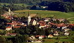 シュントルペルトの町 | |||
| |||
| 位置 | |||
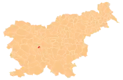 | |||
| 座標 : 北緯46度00分41秒 東経14度22分30秒 | |||
| 行政 | |||
| 国 |  スロベニア スロベニア | ||
| ドレンスカ地方 | |||
| 南東スロベニア地域 | |||
| シュントルペルト | |||
| 首長 | Rupert Gole | ||
| 地理 | |||
| 面積 | |||
| 域 | 58 km2 | ||
| 人口 | |||
| 人口 | (2008年現在) | ||
| 域 | 2,419人 | ||
| 人口密度 | 318人/km2 | ||
| その他 | |||
| 等時帯 | 中央ヨーロッパ時間 (UTC+1) | ||
| 夏時間 | 中央ヨーロッパ夏時間 (UTC+2) | ||
| 郵便番号 | 8232 | ||
| ナンバープレート | CE | ||
| 公式ウェブサイト : www.sentrupert.si | |||

脚注
- Šentrupert municipal site
- Nose, Mojca (2006) (Slovene). Regionalna geografija občine Trebnje s poudarkom na prsti in rastlinstvu: diplomsko delo [Regional Geography of the Municipality of Trebnje with Emphasis on the Soil and Vegetation]. Department of Geography, Faculty of Arts, University of Ljubljana. p. 72
- “EŠD 730” (Slovene). Registry of Immovable Cultural Heritage. Ministry of Culture of the Republic of Slovenia. 2011年7月6日閲覧。
外部リンク
This article is issued from Wikipedia. The text is licensed under Creative Commons - Attribution - Sharealike. Additional terms may apply for the media files.