エル・ウェッド県
エル・ウェッド県(El Oued)は、アルジェリアの県(ウィラーヤ)。県都はエル・ウェッド。面積46,488平方キロメートル、人口485,281人(2008年)。
エル・ウェッド県 ولاية الوادي | |
|---|---|
|
県 | |
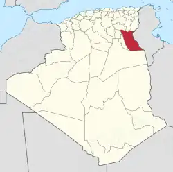 Map of Algeria highlighting El Oued | |
| 北緯33度7分 東経7度11分 | |
| 国 |
 アルジェリア アルジェリア |
| 県都 | エル・ウェッド |
| 面積 | |
| • 合計 | 46,488 km2 |
| 人口 (2008)[1] | |
| • 合計 | 485,281人 |
| • 密度 | 10人/km2 |
| 等時帯 | UTC+01 (CET) |
| 市外局番 | +213 (0) 32 |
| ISO 3166コード | DZ-39 |
| 郡 | 12 |
| 基礎自治体 | 30 |
行政区画
この県は10のダイラ(郡)と22のbaladiyahs(基礎自治体)に分けられている。
脚注
- Office National des Statistiques, Recensement General de la Population et de l’Habitat 2008 Preliminary results of the 2008 population census. Accessed on 2008-07-02.
- “Conseil de la nation: adoption du projet de loi relative à l'organisation territoriale du pays”. Algérie Presse Service (2019年12月6日). 2020年9月3日閲覧。
- “Publication de la loi portant la nouvelle organisation territoriale de l'Algérie (JO)”. Algérie Presse Service (2019年12月19日). 2020年9月15日閲覧。
This article is issued from Wikipedia. The text is licensed under Creative Commons - Attribution - Sharealike. Additional terms may apply for the media files.