タマンラセット県
タマンラセット県 (アラビア語: ولاية تمنراست, ベルベル語: Tamenγest  ) は、アルジェリア最大の県 (wilaya) である。県名は県都のタマンラセット(タマンラセト)からとられている。県には、タッシリ・ナジェール国立公園とホガール国立公園の2つの国立公園が存在し、アルジェリアの他のどの県よりも多い。
タマンラセット県 ولاية تمنراست | |
|---|---|
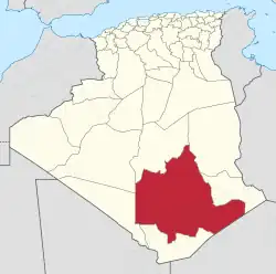 アルジェリア国内の位置 | |
| 北緯22度47分 東経05度31分 | |
| 国 |
 アルジェリア アルジェリア |
| 県都 | タマンラセット |
| 面積 | |
| • 合計 | 320,075 km2 |
| 人口 (2008年)[1] | |
| • 合計 | 115,043人 |
| • 密度 | 0.36人/km2 |
| 等時帯 | UTC+01 (CET) |
| 市外局番 | +213 (0) 29 |
| ISO 3166コード | DZ-11 |
| 郡 | 3 |
| コミューン | 5 |
かつてはアルジェリア中部から南部のマリ共和国・ニジェールとの三国国境地点まで、国土のほぼ4分の1にあたる55.6万平方キロメートルが領域であったが、2019年12月に北部の2郡がイン・サラー県として、南部の2郡がイン・ゲザム県として分離[2][3]。その後の面積は32万平方キロメートルとなっている。
出典
- Office National des Statistiques, Recensement General de la Population et de l’Habitat 2008 Archived 2009年7月10日, at the Wayback Machine. Preliminary results of the 2008 population census. Accessed on 2008-07-02.
- “Conseil de la nation: adoption du projet de loi relative à l'organisation territoriale du pays”. Algérie Presse Service (2019年12月6日). 2020年9月3日閲覧。
- “Publication de la loi portant la nouvelle organisation territoriale de l'Algérie (JO)”. Algérie Presse Service (2019年12月19日). 2020年9月15日閲覧。
- “The official journal of People's Democratic Republic of Algeria” (PDF). SGG Algeria. 2007年11月6日閲覧。
This article is issued from Wikipedia. The text is licensed under Creative Commons - Attribution - Sharealike. Additional terms may apply for the media files.