ベシャール県
ベシャール県(Béchar)は、アルジェリアの県(ウィラーヤ)。県都はベシャール。面積50,890平方キロメートル、人口221,467人(2008年)。
ベシャール県 ولاية بشار | |
|---|---|
|
県 | |
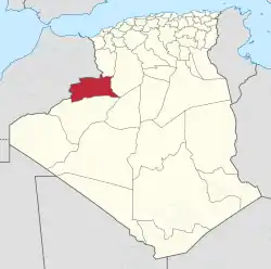 Map of Algeria highlighting Béchar | |
| 北緯31度37分 西経2度13分 | |
| 国 |
 アルジェリア アルジェリア |
| 県都 | ベシャール |
| 面積 | |
| • 合計 | 50,890 km2 |
| 標高 | 605 m |
| 人口 (2008)[1] | |
| • 合計 | 221,467人 |
| • 密度 | 4.4人/km2 |
| 等時帯 | UTC+01 (CET) |
| 市外局番 | +213 (0) 29 |
| ISO 3166コード | DZ-08 |
| 郡 | 6 |
| 基礎自治体 | 11 |
県の大部分はとくにグレート・ウェスタン・エルグやEr Raouiエルグといった住めない砂丘に覆われ、または乾燥した平原が占めている。よって住民の多くはサウーラ谷の周辺のオアシスに集中して居住する。主な資源のうち、石炭は県北部のベシャールやKenadsaにあり、銅は南部のDjebel Ben Tagineにある。[2]
2019年12月に南部にあった6郡がベニ・アッベス県として分離した[3][4]。これにより面積は16万平方キロメートルから大幅に縮小したが、前述の人が住めない地域が多くを占めていたため人口は約5万人の減少にとどまっている。
脚注
- Office National des Statistiques, Recensement General de la Population et de l’Habitat 2008 Archived 2008年7月24日, at the Wayback Machine.2008年人口調査データ。2008-07-02閲覧(リンク切れ)
- “アーカイブされたコピー”. 2010年11月18日時点のオリジナルよりアーカイブ。2010年9月19日閲覧。
- “Conseil de la nation: adoption du projet de loi relative à l'organisation territoriale du pays”. Algérie Presse Service (2019年12月6日). 2020年9月3日閲覧。
- “Publication de la loi portant la nouvelle organisation territoriale de l'Algérie (JO)”. Algérie Presse Service (2019年12月19日). 2020年9月15日閲覧。
- “Dairas Et Communes” (French). Site Officiel de la Wilaya de Bechar. 2013年2月16日時点のオリジナルよりアーカイブ。2013年3月9日閲覧。
This article is issued from Wikipedia. The text is licensed under Creative Commons - Attribution - Sharealike. Additional terms may apply for the media files.