ワルグラ県
ワルグラ県(アラビア語: ولاية ورقلة)は、アルジェリア東部の県(ウィラーヤ)。県都はワルグラ。その他ハッシ・メサウドの各都市がある。イサワーヌ砂漠が広がる。
ワルグラ県 ولاية ورقلة | |
|---|---|
|
県 | |
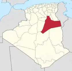 アルジェリアにおける位置図 | |
| 北緯31度57分 東経5度19分 | |
| 国 |
 アルジェリア アルジェリア |
| 県都 | ワルグラ |
| 面積 | |
| • 合計 | 202,202 km2 |
| 人口 (2008年)[1] | |
| • 合計 | 311,337人 |
| • 密度 | 1.5人/km2 |
| 等時帯 | UTC+01 (中央ヨーロッパ時間) |
| 郵便番号 | +213 32 |
| ISO 3166コード | DZ-30 |
| 郡 | 6 |
| コミューン | 10 |
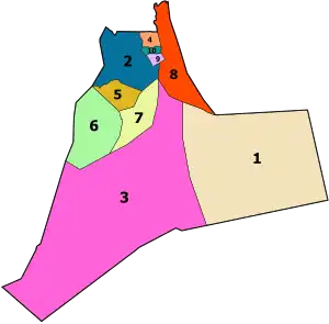
2019年までの県内の各郡の位置。図中の番号は記事の表に対応している
行政区分
ワルグラ県は、6の郡(ダイラ)と10のコミューン(市町村)からなる[4]。
郡
- エル・ボルマ
- エル・ハジラ
- ハッシ・メサウド
- (メガリーヌ) - トゥーグラ県として分離
- ングサ
- ワルグラ
- シディ・フィレド
- (タイベト) - 分離
- (テマシーヌ) - 同上
- (トゥーグラ) - 同上
コミューン
- アイン・ベイダ
- エル・アリーヤ
- エル・ボルマ
- エル・ハジラ
- ハッシ・ベン・アブドゥッラー
- ハッシ・メサウド
- ングサ
- ワルグラ
- リッサート
- シディ・フィレド
脚注
- Office National des Statistiques, Recensement General de la Population et de l’Habitat 2008 Archived 2008年7月24日, at the Wayback Machine. Preliminary results of the 2008 population census. Accessed on 2008-07-02.
- “Conseil de la nation: adoption du projet de loi relative à l'organisation territoriale du pays”. Algérie Presse Service (2019年12月6日). 2020年9月3日閲覧。
- “Publication de la loi portant la nouvelle organisation territoriale de l'Algérie (JO)”. Algérie Presse Service (2019年12月19日). 2020年9月15日閲覧。
- “Official website of the province of Ouargla - state” (Arabic). 2013年2月25日閲覧。
This article is issued from Wikipedia. The text is licensed under Creative Commons - Attribution - Sharealike. Additional terms may apply for the media files.