ガルダイア県
ガルダイア県(アラビア語: ولاية غرداية、フランス語: Wilaya de Ghardaïa、モザビテ語:  )は、アルジェリア東部の県(ウィラーヤ)。県都はガルダイアである。世界遺産のムザブがある。
ガルダイア県 ولاية غرداية | |
|---|---|
|
県 | |
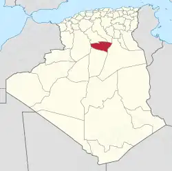 ガルダイア県の位置 | |
| 北緯32度29分 東経3度40分 | |
| 国 |
 アルジェリア アルジェリア |
| 県都 | ガルダイア |
| 政府 | |
| • 県議会議長 | フェカール・モハメド(FLN) |
| • 知事 | フェヒム・イェヒア |
| 面積 | |
| • 合計 | 22,782 km2 |
| 人口 (2008年)[1] | |
| • 合計 | 299,111人 |
| • 密度 | 13人/km2 |
| 等時帯 | UTC+01 (中央ヨーロッパ時間) |
| 郵便番号 | +213 (0) 29 |
| ISO 3166コード | DZ-47 |
| 郡 | 9 |
| コミューン | 13 |
行政区画
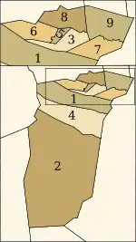
郡の区画
7つの郡と9の基礎自治体(コミューン)が置かれている。
郡
- メトリリ郡
- (エル・メニア郡) - エル・メニア県として分離
- ブーヌーラ郡
- (マンスーラ郡) - 分離
- ガルダイア郡
- ダヤート・ベンダーワ郡
- ゼルファナ郡
- ベリアン郡
- エル・ゲラーラ郡
コミューン
- ベリアン
- ブーヌーラ
- ダヤート・ベンダーワ
- エル=アットゥフ
- エル・ゲラーラ
- ガルダイア
- メトリリ
- セブセブ
- ゼルファナ
脚注
- Office National des Statistiques, Recensement General de la Population et de l’Habitat 2008 Preliminary results of the 2008 population census. Accessed on 2008-07-02.
- “Conseil de la nation: adoption du projet de loi relative à l'organisation territoriale du pays”. Algérie Presse Service (2019年12月6日). 2020年9月3日閲覧。
- “Publication de la loi portant la nouvelle organisation territoriale de l'Algérie (JO)”. Algérie Presse Service (2019年12月19日). 2020年9月15日閲覧。
関連項目
- ベルベル人
- ムザブ人
外部リンク
- 公式サイト (フランス語)
This article is issued from Wikipedia. The text is licensed under Creative Commons - Attribution - Sharealike. Additional terms may apply for the media files.