タウポ湖
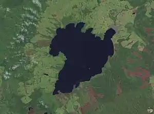
タウポ湖(Lake Taupo)は、ニュージーランド北島のタウポに位置する、ニュージーランド最大の表面積(616km²)を持つ湖。
| タウポ湖 | |
|---|---|
 | |
| 所在地 | ニュージーランド北島 |
| 面積 | 616 km2 |
| 周囲長 | 193 km |
| 最大水深 | 186 m |
| 淡水・汽水 | 淡水湖 |
| 湖沼型 | カルデラ湖 |
 プロジェクト 地形 プロジェクト 地形 | |
西暦181年の巨大噴火(VEI7、噴煙高度50km)によってできたカルデラ湖。付近では現在も火山活動が活発で、温泉や地熱発電所がある。
26,500年前には、VEI8の巨大噴火(Oruanui eruption、噴出量は1170立方km、過去7万年で最大規模)を起こしている。
ワイカト川が流れ出ている。水質としてはリンが非常に多いものの、流入する窒素が非常に少ないために貧栄養状態にあり、透明度が高く非常に良好な水質を維持している[1]。
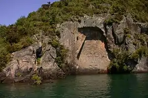
タウポ湖畔マイン・ベイの南端の断崖には、マオリの彫刻がある。
文献
- Ben G. Mason; David M. Pyle, and Clive Oppenheimer (2004). “The size and frequency of the largest explosive eruptions on Earth” (PDF). Bulletin of Volcanology 66 (8): 735-748. doi:10.1007/s00445-004-0355-9 2006年7月14日閲覧。.
脚注
- 倉田亮 『世界の湖と水環境』p57 成山堂書店、2001年、ISBN 4-425-85041-6
外部リンク
- Destination Lake Taupo
- Turangi and Lake Taupo Website
- Lake Taupo Webcam
- Taupo Volcanic Zone
- History and legends of Lake Taupo
- Lake Taupo water quality (includes bathymetric map)
- Flickr.com Photos tagged with laketaupo & taupo
This article is issued from Wikipedia. The text is licensed under Creative Commons - Attribution - Sharealike. Additional terms may apply for the media files.