アベニューI駅
アベニューI駅(Avenue I)はブルックリン区のアベニューIとマクドナルド・アベニュー交差点に位置するニューヨーク市地下鉄INDカルバー線の駅で、F系統が終日停車する。
| |||||||
|---|---|---|---|---|---|---|---|
%253B_1st_Generation_PA-CIS-1.jpg.webp) コニー・アイランド方面ホーム
| |||||||
| 駅情報 | |||||||
| 住所 |
Avenue I & McDonald Avenue Brooklyn, NY 11230 | ||||||
| 区 | ブルックリン区 | ||||||
| 地区 | ミッドウッド、メープルトン | ||||||
| 座標 | 北緯40度37分33.32秒 西経73度58分34.39秒 | ||||||
| ディビジョン | Bディビジョン(IND、旧BMT) | ||||||
| 路線 |
INDカルバー線 (旧BMTカルバー線) | ||||||
| 運行系統 |
F  (終日) <F> (終日) <F> (ラッシュ時のみ) (ラッシュ時のみ) | ||||||
| 接続 |
 NYCTバス: B11[1][2] NYCTバス: B11[1][2] | ||||||
| 構造 | 高架駅 | ||||||
| ホーム数 | 相対式ホーム 2面 | ||||||
| 線路数 | 3線 (2線を使用中) | ||||||
| その他の情報 | |||||||
| 開業日 | 1919年3月16日 | ||||||
| 旧駅名/名称 |
パークヴィル駅 Parkville | ||||||
| 利用状況 | |||||||
| 乗客数 (2017) | 326,469[3]人  44.2% 44.2% | ||||||
| 順位 | 414位(425駅中) | ||||||
| 次の停車駅 | |||||||
| 北側の隣駅 |
18番街駅: F <F> | ||||||
| 南側の隣駅 |
ベイ・パークウェイ駅: F <F> | ||||||
| |||||||
駅構造
配線図 | |||||||||||||||||||||||||||||||||||||||||||||||||||||||||||||||||||||||||||||||||||||||||||||||
|---|---|---|---|---|---|---|---|---|---|---|---|---|---|---|---|---|---|---|---|---|---|---|---|---|---|---|---|---|---|---|---|---|---|---|---|---|---|---|---|---|---|---|---|---|---|---|---|---|---|---|---|---|---|---|---|---|---|---|---|---|---|---|---|---|---|---|---|---|---|---|---|---|---|---|---|---|---|---|---|---|---|---|---|---|---|---|---|---|---|---|---|---|---|---|---|
| |||||||||||||||||||||||||||||||||||||||||||||||||||||||||||||||||||||||||||||||||||||||||||||||


| P ホーム階 |
相対式ホーム、右側ドアが開く | |
| 北行緩行線 | ←   ジャマイカ-179丁目駅行き(18番街駅) ジャマイカ-179丁目駅行き(18番街駅) | |
| 混雑方向 急行線 |
→ 定期列車なし | |
| 南行緩行線 | → コニー・アイランド-スティルウェル・アベニュー駅行き(ベイ・パークウェイ駅)→ | |
| 相対式ホーム、右側ドアが開く | ||
| M | 改札階 | 改札口、駅員詰所、メトロカード自動券売機 |
| G | 地上階 | 出入口 |
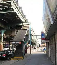
交差点北西の階段
駅は1919年3月16日に開業[4][5]、相対式ホーム2面3線の高架駅であるが中央の急行線は使用されていない[6][7][8]。ホーム北端を除く全体に緑色の屋根が架かっている[9]。
2016年6月7日から2017年5月1日まで南行ホームが[10][11]、2017年5月22日から2018年7月30日まで北行ホームが改装された[12][13]。
脚注
- MTA Regional Bus Operations. "B11 bus schedule" (PDF). 2020年10月11日閲覧。
- “Brooklyn Bus Map” (PDF). Metropolitan Transportation Authority (2017年11月). 2018年4月24日閲覧。
- “Facts and Figures: Annual Subway Ridership 2013–2018”. メトロポリタン・トランスポーテーション・オーソリティ (2019年7月18日). 2019年7月18日閲覧。
- (英語) Legislative Documents. J.B. Lyon Company. (January 1, 1920)
- Eisenstadt, Peter R.; Moss, Laura-Eve (January 1, 2005) (英語). The Encyclopedia of New York State. Syracuse University Press. ISBN 9780815608080
- “Tracks of the New York City Subway”. Tracks of the New York City Subway. 2015年10月9日閲覧。
- Marrero, Robert (2015年9月13日). “469 Stations, 846 Miles”. B24 Blog, via Dropbox. 2015年10月9日閲覧。
- “Feasibility and Analysis of F Express Service in Brooklyn”. Metropolitan Transportation Authority. (2016年5月) 2016年6月24日閲覧。
- Cox, Jeremiah. “Avenue I (F) - The SubwayNut”. www.subwaynut.com. 2016年10月9日閲覧。
- “Feasibility and Analysis of F Express Service in Brooklyn”. Metropolitan Transportation Authority. (2016年5月) 2016年6月24日閲覧。
- “Coney Island-bound F subway trains will not stop at Avenue I, Bay Pkwy, Avenue N, Avenue P, Avenue U, and Avenue X until early 2017”. web.mta.info. Metropolitan Transportation Authority (2016年). 2016年5月27日時点のオリジナルよりアーカイブ。2016年10月9日閲覧。
- “New York City Subway Map”. mta.info. Metropolitan Transportation Authority (2017年5月1日). 2017年5月10日時点のオリジナルよりアーカイブ。2017年5月2日閲覧。
- “$140 Million Culver F subway Line Station Renewal Project Begins Next Phase”. web.mta.info. Metropolitan Transportation Authority (2017年5月18日). 2017年5月18日閲覧。
- “MTA Neighborhood Maps: Borough Park”. mta.info. Metropolitan Transportation Authority (2015年). 2017年1月1日閲覧。
外部リンク
- nycsubway.org – BMT Culver Line: Avenue
- Station Reporter — F Train
- The Subway Nut — Avenue I Pictures
- Avenue I entrance from Google Maps Street View
- Avenue J entrance from Google Maps Street View
- Platforms from Google Maps Street View (Pre-2016-2018 Renovation)
- Platforms from Google Maps Street View (During 2016-2018 Renovation)
This article is issued from Wikipedia. The text is licensed under Creative Commons - Attribution - Sharealike. Additional terms may apply for the media files.